Crystal Beach and Galveston, Texas

Yikes! It’s a Rain Forest in Here

After a wild night of thunder, wind gusts that rocked the trailer, and rain pounding the roof and windows, we woke to cloudy skies and calmer winds. Leaving Bryan, Texas, behind on February 21, 2018, we headed toward Crystal Beach, Texas, to attend our niece’s wedding on Saturday.

The rain started up again and the temperature rose from 40 to 70 degrees. A few miles outside of Houston, we stopped at a rest area for a break. When I opened the door the odor and feel of a rain forest smacked me in the face. The walls, cabinets, and all the surfaces inside the trailer dripped with moisture. Condensation obliterated the view through the windows. The fabric furniture, towels, and jackets were all damp. What the heck, did we spring a leak? If so, there wasn’t anything we could do about it while on the road. We had to get to our next location fast before too much damage occurred.

Thank goodness, the clouds had cleared and the sky was sunny when we arrived at Lazy D & D RV Resort.

IMG_6438 - Copy.jpg
Lazy D & D RV Resort Office with Restrooms and Laundry Upstairs

I latched the door open and cranked out the air vents and windows. Beach towels soaked up the moisture on the walls, cabinets, and windows. On hands and knees, I ran my hands on the carpeting in the closet, under the bed, along the bedroom floor, around the mattress and bedding. Nothing found to indicate a leak.

“Hey, I found condensation on all the tools in the toolbox in the bed of the pickup. Maybe there is no leak,” Jon said. “No, there’s got to be a leak?” I said. The only thing we could figure out is that the humidity had been so high, moisture built up inside the fifth wheel. This was something we had never experienced before and don’t care to face again. Another hour or so and damage to the interior would have been severe. For the next few days, I still searched for the nonexistent leak, just in case.

While I searched for the leak and Jon set up the trailer, muscovy ducks waddled and grackles strutted around the trailer. Grackles are my new favorite bird for their whistles, squeaks, and croaks, but especially the guttural crackle noise they make and also for the way they make their tails stick out sideways as the walk. I should have recorded their songs because now I miss their serenade.

IMG_6272 - Copy
Muscovy Ducks Walked Around the RV Park Like Security Guards
grackle-with-long-tail-3066964_1280
Grackles Woke us up in the Morning and Serenaded us All Day (photo used under CC0 from Pixabay https://pixabay.com/en/grackle-with-long-tail-tropic-bird-3066964) 

Don’t Let Your Anger Show

 Word to the wise when taking the Galveston-Bolivar Port ferry across SH 87: Don’t show anger while waiting your turn for the ferry. A dump truck pulled up behind us. He talked to himself and waved his arms about, appearing agitated. When he saw other vehicles boarding before our lane, the driver yelled, cussed, and honked his horn. After a few minutes, the loader directed the vehicles in our lane to the ferry. She waved us through but signaled the dump truck driver to pull over into another lane.

As the ferry pulled away from the port, we saw the dump truck waiting on shore. Take that, dump truck driver.

IMG_6283 - Copy
Ferry to Galveston from Bolivar Port

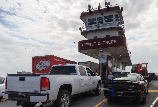
The State Department of Transportation operates the ferry and there is no fee. The ride took about twenty minutes and we only had to wait about ten minutes for it to arrive. On our way back, we drove right on without any wait at all.
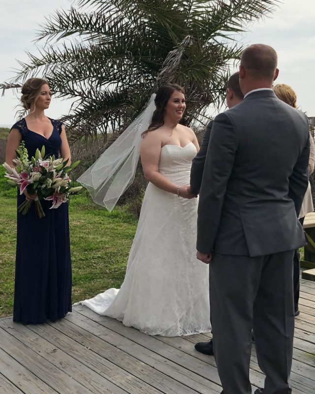
IMG_6284 - Copy
Seagulls Waiting for Handout
IMG_6294 - Copy
Seawolf Park on Galveston’s Pelican Island Where a Submarine, Merchant Ship, and Destroyer Can be Seen
IMG_6296 - Copy
Texas Flag on Ferry

The Wedding

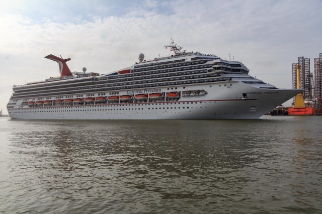
We attended the fastest wedding and reception ever on Saturday, February 24, 2018. After three days of fog, we woke up to puffy clouds and bright sky along with a slight breeze, a perfect day for a wedding on the beach. We arrived at the beach house around 9:15 a.m. noting travel bags packed and lined up in front of the house for the 30 people who would board a cruise ship later in the day. The ceremony began at 9:45 a.m., formal photography session at 10:15 a.m., catered lunch at 10:45 a.m., champagne and toasts at 11:15, cake cutting at 11:30, and at 12:00 p.m., we waved at the bus as it whisked the wedding party and guests off to the cruise ship. Wham. Bam. The deed was done. I suspect, though, the merriment continued on board the ship.

IMG_1752 - Copy
Our Niece Jessi Blackwell and her Father Chris Blackwell
IMG_1761 - Copy
Best Man and Maid of Honor Tracy Blackwell Oversee the Ceremony and Vows

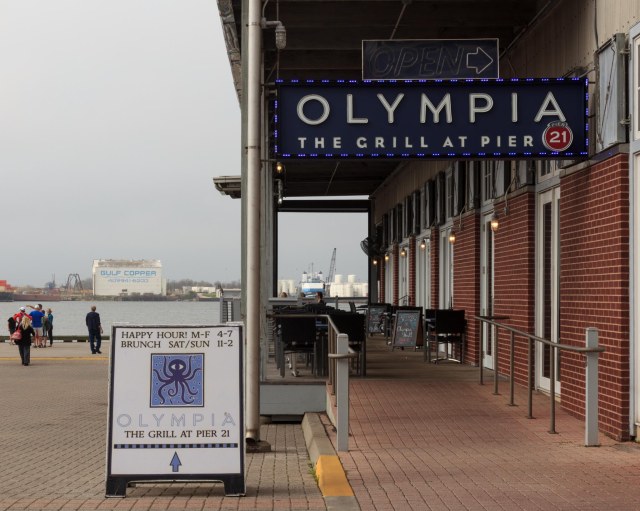
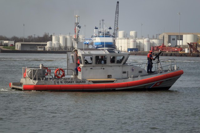
We hopped in our truck and headed for Galveston. A plate of fried calamari and a couple of Mai Tais at Olympia Grill on Pier 21 kept us busy while we waited for the Coast Guard to escort the ship out to sea.

IMG_6314 - Copy
Olympia the Grill at Pier 21 on the Harborfront
IMG_6348 - Copy
U.S. Coast Guard Escort for Cruise Ship
IMG_6349 - Copy
Carnival Freedom Heading out to Sea

We stopped in at The Great Storm Theater, which tells the story of the September 8, 1900, Galveston Hurricane through the personal stories of some of the survivors and the recovery required to rebuild the city.

IMG_6390 - Copy
Great Storm Theater

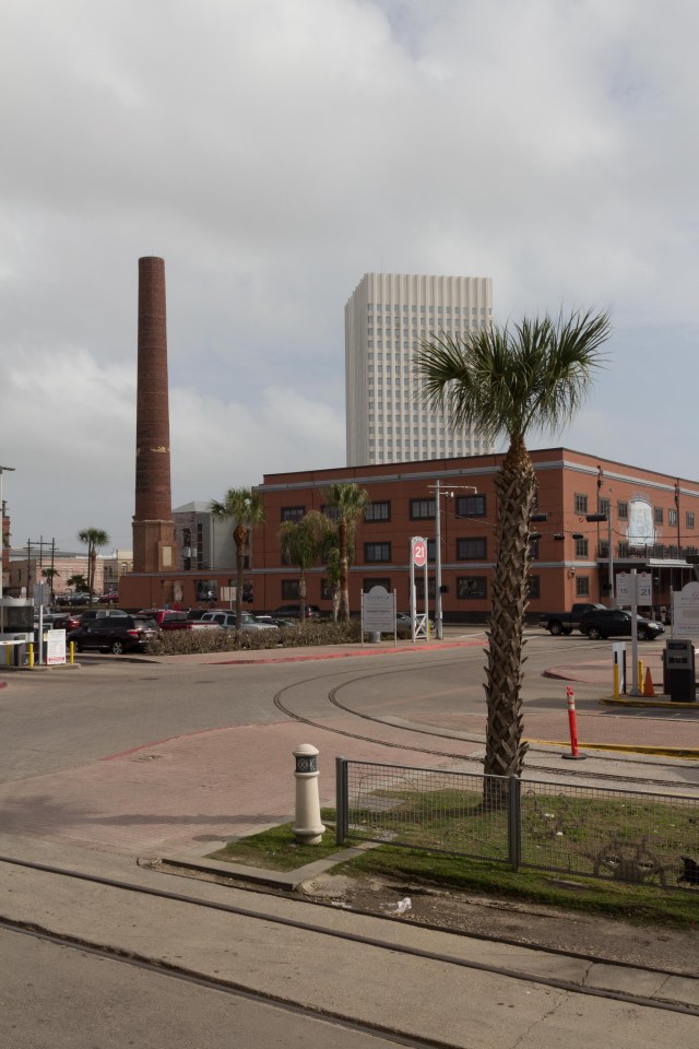
A few more sites near Pier 21.

IMG_6389 - Copy
Statue of Boy and Seagulls
IMG_6336 - Copy
Juxtaposition of Old and New Is Around Every Corner in Galveston Harbor and Strand Districts
IMG_6334 - Copy
She’ll be Coming Around the Corner When She Comes

More photos and information about sites on Bolivar Peninsula coming up in next post.

Safe Travels


Tri-Cities Wrap Up and On to Oregon

Sacajawea State Park

Our last visit in the Tri-Cities area was the Sacajawea Historical State Park and the Sacajawea Interpretive Center along the Columbia River.


IMG_3618
Sacajawea Interpretive Center


The museum tells the story of Sacagawea, her husband, and the Lewis and Clark expedition near the site where the party made camp for two nights at the confluence of the Snake and Columbia Rivers while traveling to the Pacific Ocean. Other displays include the stories of the Native Americans who resided in the area.


IMG_3612
Sacajawea Interpretive Center

Why the different spelling of the Shoshoni woman? Recent research and study of the original journals indicate the proper spelling and pronunciation with a hard ‘g’ not a ‘j.’ The name of the state park kept the original spelling.


IMG_3620
Sacajawea State Park

Besides the Sacajawea Center, the 257-acre day-use park includes two boat ramps, fishing, swimming, boating, and 1.2 miles of hiking trails.


IMG_3616
View of Rail Bridge from Sacajawea State Park

We made one more visit to the Ice Harbor before we left the area. This time we opted for the Clover Island Marina location, which is an upscale version that includes a more inviting building, more food selections, and the same great beer.


IMG_3609
Ice Harbor Brewing Company at the Marina
IMG_3608
Cable Bridge 

The American Empress came into view near the harbor so I managed to snap this photo between the trees. I wish I could have gotten the paddle wheel. The steamboat vessel cruises the Columbia and Snake Rivers along the Lewis and Clark trail.

IMG_3668
Glimpse of American Empress 


After spending the past couple of weeks in noisy locations near or on major highways and freeways, we craved a quiet place. We made reservations at Crooked River Ranch RV Park near Redmond, Oregon and crossed our fingers that it would satisfy our craving.

On to Oregon

 On Sunday, July 23, 2017, we followed the Columbia River through golden cliffs, rivers the width of small lakes, windmills on top of cliffs, a few farms, of course, and Mount Rainier poking his snowcapped peak above the terrain. In Washington, the air had a smoke haze look to it, but cleared as we entered Oregon. At one point, we could see the snowcapped peaks of Mt. Rainier, Mt. Hood, Mt. Jefferson, and the Three Sisters. What a sight.

When we arrived at Crooked River Ranch RV Park, we were pleased to find that for at least three nights we would be far from any major roads.


IMG_3695
Sunset View of Cliffs from Crooked River Ranch


Newberry National Volcanic Memorial Park

The next day we visited the Newberry National Volcanic Memorial Park. We arrived just in time to hear a ranger talk on the geology of the park. Afterward, we took a hike with him partially up Lava Butte, a cinder cone, where he pointed out examples of what he had discussed on the patio.


IMG_3692
Lava Butte Kind of Looks Like a Dinosaur Back


IMG_3674
Path Around the Lava Flow

A shuttle bus took us to the top of Lava Butte where there were magnificent views of the valley below and peaks to the west. The lava flow reminded us of Craters of the Moon in Idaho.


IMG_3687
Lava Butte
IMG_3681
View From Atop Lava Butte


Lava Butte erupted 7,000 years ago creating a 9 square mile lava flow. Besides Lava Butte, visitors can see Lava River Cave, Big Obsidian Flow, and Paulina Falls and Paulina Peak, which rises 7,984 feet. Hikers, horse riders, and bicyclists can enjoy the many trails within the park that range from easy to difficult. Several tent campsites are available in the Newberry Caldera and East Lake has one RV campground with 45 sites, all of which are reservable, while the tent sites have some first-come-first-served sites.

Sisters Oregon

We also visited Sisters, Oregon, a small town of less than 2 square miles and a population of 2,038 as of the 2010 census. We found Sisters a quaint little town with plenty of stores to keep any shopper busy, restaurants to satisfy hunger, and places to rest at night.


IMG_3722
Sisters Market
IMG_3723
Baskets of Petunias Hang from Lightposts
IMG_3725
Loved the Restored Buildings
IMG_3727
For Cooking Equipment and Utensils, Stop in at The Cook’s Nook
IMG_3729
It was Too Early in the Day to Grab a Cold One at Sisters Saloon


A small park with a couple picnic tables was the perfect place for us to eat our packed lunch before heading to the Whychus Creek Overlook Trail.


IMG_3734
View from Whychus Creek Overlook Trail


IMG_3732
Whychus Creek Overlook


Continuing down the road, we came across a burned out area giving way to views of the peaks.


IMG_3750
Peaks Rise Above a Burned Out Area
IMG_3745
Naked Trees Against Blue Skies and Clouds
IMG_3747
Signs of Forest Rebirth

On our way back to Crooked Ranch, we drove by alpaca grazing in a field.


IMG_3754
Alpaca Grazing in a Field

There are a total of four alpaca farms in the Bend, Oregon, area. We come across a lot of cows and cattle in our travels, but this was the first time we saw alpacas.


Peter Skene Ogden State Scenic Viewpoint

We stopped in at the Peter Skene Ogden State Scenic Viewpoint in Terrebonne, Oregon. The viewpoint includes views of basalt cliffs, river, and peaks along with the closed Rex T. Barber Veterans Memorial Bridge. Several signs warn visitors to watch children at all times and leave pets in the car.

IMG_3699
Keep Children and Dogs Safe


IMG_3712
Rex T. Barber Veterans Memorial Bridge U.S. Highway 97
IMG_3717
Detail of Cliffs at Peter Skene Ogden State Scenic Viewpoint
IMG_3707
View From Top of Cliff Down to River
IMG_3711
Crooked River High Bridge Built in 1926 Now Closed to Traffic
IMG_3701
Trunk Railroad Bridge
IMG_3714
Canyon Below Trunk Railroad Bridge

The night before leaving Crooked River Ranch, smoke drifted into the valley creating a spectacular sunset view of the hills and sky beyond the bridge.


IMG_3766
Rex T. Barber Veterans Memorial Bridge U.S. Highway 97


Next up we continue searching for out of way places and Jon redeems a Christmas gift.

Safe Travels