The first destination on our 2023 Fall Adventure was Marshfield, Missouri, where our daughter, Laura, and her family had settled into their new home. Her hope chest didn’t fit in their moving pod when her husband, Chris, loaded up their belongings, so we volunteered to deliver it. We’d figure out where to go and what to see after the delivery once we made the 7-day trek.
We hit the road on Friday, September 8, 2023. After our awful experience with Interstate 40 during the spring, we opted for highways 50 and 70, also referred to as the Loneliest Road in America.
First stop Fallon Nevada. Thank goodness we missed the deluge that disrupted the Burning Man event 120 miles to the north of us. Then on to Ely Nevada. The wide shoulder outside Austin, Nevada, was a perfect place to take a break. I would have preferred to walk over and explore the gravesites and monuments at the nearby Austin Cemetery. Instead, I snapped a shot from afar. The cemetery earned distinction on the National Register of Historic Places in 2003.
Jon bundled the hope chest inside blankets, covered it with a tarp, and secured it to the rear hitch rack.
Austin Cemetery
We stopped in Eureka, Nevada, and ate delicious giant burgers at the Owl Club Bar and Steakhouse for lunch. I noticed a recurring theme of red paint with white trim on buildings around town. I imagined a group of people with ladders, brushes, and rollers roaming around, painting the town red.
Owl Club Bar and Steakhouse
Eureka historic buildings
Closed sign on the tourist information door.
1879 Court House
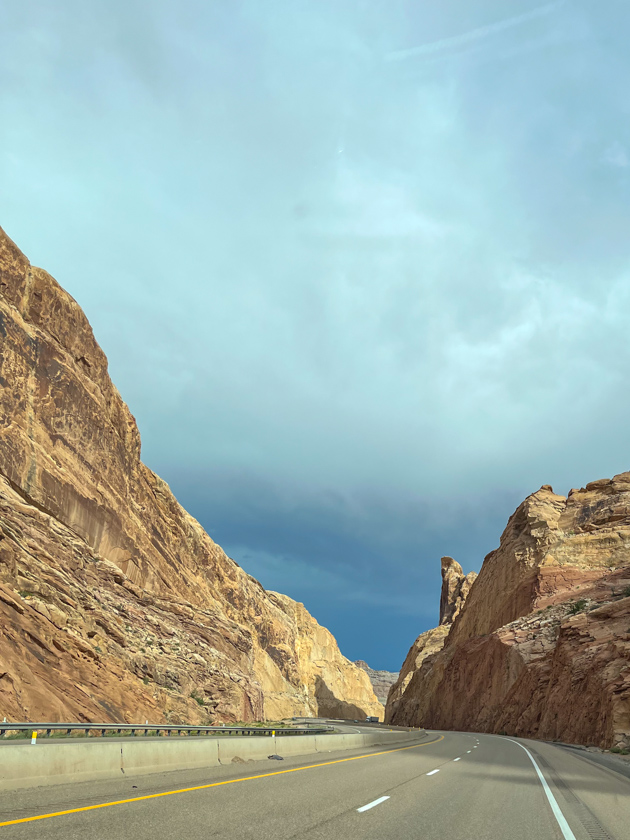
The beautiful canyon we drove through from Ely to Green River nearly made me cry. The painted cliffs in rust and orange and yellow were every bit as majestic from the passenger seat as it would have been up close.
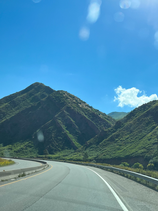
On the way to our next stop, we encountered a contrast to the terrain from what we saw in Utah. The Utah rock gave way to cliffs clothed in grasses, bushes, and trees.
And then we gawked at the architectural genius that skirted the cliff like a tutu. Was it really westbound Interstate 70 up there?
Whoa, is that the interstate?
On paper, Denver West/City Center KOA seemed an easy side trip to avoid afternoon traffic in the big city. If I’d only known about the altitude, I might have chosen another location. While Denver sits at an elevation of 5,280 feet, the KOA is nearly 8,500 feet. Although we both had trouble navigating the hill from and to the fifth wheel and the store, it was the hot steamy shower that did me in. The combination of the steam and altitude had me gasping for breath. Note to self, don’t take a steamy hot shower in high altitude.
The hill to the store was steeper than it looks here
On September 12, 2023, we selected Wakeeney, Kansas, for our next stop, halfway between Denver and Kansas City.
We cut it close—I was driving, so I should say I cut it close—the next day when we (I) pulled into the fuel station with only 1.12 gallons of diesel left in the tank. Yikes!
While eating a late breakfast, at Cracker Barrel of course, we discussed finding a spot to stay the night or continue on to Marshfield, Missouri. The back-to-back long drives had worn me down, so I voted to press forward and make our trip six days instead of seven. Jon preferred to park and start off early in the morning. Trading off driving duty made it possible for us to make it all the way through. We won’t do that again soon. Seven hours on the map usually means eight or nine hours after stopping for food and fuel.
As the sun dropped below the horizon, we pulled into C&L Homestead and placed the trailer beside Chris’ workshop. I was so thankful we pushed through because we had two weeks ahead of us without packing and moving down the highway.
Finally, C & L Homestead
Up Next: A look around the homestead and the local area.
In this episode, we wrap up our trip to New Mexico. Thursday, July 22, 2021, was decision time. Do we turn the truck for home? No. We weren’t quite ready. Not yet. Hey, Twin Falls was only about 720 miles away, albeit mostly north rather than west. We could make that drive in a couple of days. So, the next day, we loaded up, hooked up, and climbed into the cab.
Depiction of Powell and his crew on an expedition at the Wesley Powell River History Museum
Green River
Shady Acres in Green River, Utah, looked like a good place to stop for a couple of nights. We’d have time to catch up on the laundry, the museum in town looked interesting, and we could visit Green River Coffee Shop. We had picked up a nice batch of freshly roasted decaf coffee beans and pastries at the coffee shop the last time we drove through town.
Campsite at Shady Acres
The Green River Golf Course and farm land surrounds the RV park.
From the museum looking north up the Green River
J.W. Powell River History Museum entrance
Panels and artifact displays tell about the river’s history, geology, and the people who lived and ran the river.
Details in the statue’s base depict scenes from Powell’s expeditions.
This metate is only one of many artifacts displayed.
Running Rapids
Dinosaur exhibit with Utahceratops gettyi
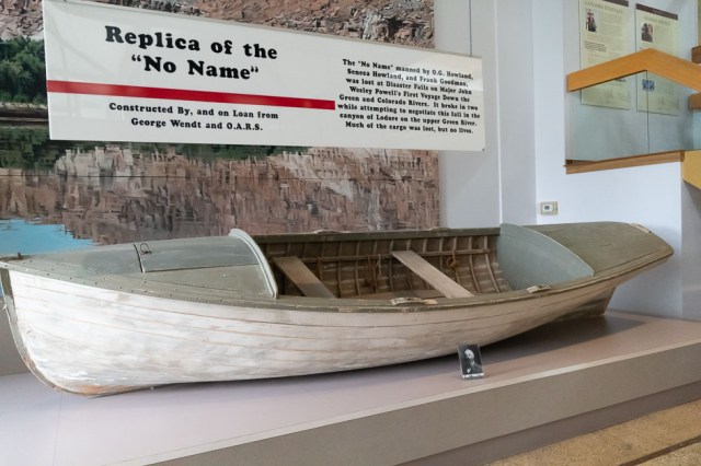
The Boat Room shows different styles of river boats that navigated the rapids, including this bull boat. American Indians and frontiersmen used boats made of wooden frames and covered with buffalo hides.
The boat No Name met its fate at Disaster Falls when it broke in two during John Wesley Powell’s first voyage down the Green and Colorado Rivers. No lives were lost, only cargo.
This was Norman Davies Nevills boat used in the 1940s.
Sample of paintings in the art gallery. Carol Bold paintings: Reflections Adrift, Winding Around the Bend, and Preserve the Reserve.
Outside, next to the museum, is a walking path along the river.
Main Street’s Green River Bridge
Here are a couple of unexpected sights in the museum’s parking lot.
Need a charge traveling I70 in Utah? Tesla has a charge station in the museum’s parking lot.
Watermelon used as a float in the Melon Days Parade?
Sadly, there were no coffee beans for sale on this trip, and the muffin we shared was not what we remembered. Oh well. We were still in the middle of a pandemic and our laundry piles were waiting for us back at the trailer.
John Wesley Powell River History Museum
Jon and I spent a good part of two hours exploring the John Wesley Powell River History Museum. Betsy Hatt, “in memory of Vail Hatt and his commitment to the betterment of the community and tourism,” donated the property where the museum stands.
Conceived in 1987, the 23,000 square foot museum opened its doors in 1990. It is owned and operated by the city in partnership with the John Wesley Powell River History Museum, Inc., established in 2008 as a non-profit organization.
We enjoyed wandering through the historical exhibits and reading the information panels, as well as the art exhibit and the science exhibit featuring dinosaurs. The museum’s focus is on the impact that exploration of the Green and Colorado rivers had on the history and culture of Southeastern Utah.
Visitors will find historical exhibits detailing the Crossroads of the West, John Wesley Powell, the River Runner’s Hall of Fame, and the Boat Room. Temporary art exhibits are also available for viewing.
One of the most notable observations we made about the town of Green River was how neat and clean everything was. Most of the properties, whether occupied or not, had been swept clean of debris and landscaped with flowers planted in barrels.
Following our two-night stay in Green River, we headed north to Twin Falls, Idaho, where our friends Sonia and Marv Baima had moved to from Sparks, Nevada.
Twin Falls, Idaho
On our way to Twin Falls, we stopped for lunch at the Tangerine Eatery in Price, Utah. They serve healthy choices for breakfast, lunch, and dinner. And patrons will find plenty of toppings for their favorite frozen yogurt selection.
We arrived at Twin Falls KOA around 6:30 p.m. after a long drive from Green River. We met up with our friends, Sonia and Marv Bamai for breakfast then went to Shoshone Falls to gawk at the Snake River rushing over the boulders and cliffs. Then headed downtown for good eats and beer at Koto.
Rainbow in the Mist 1
Rainbow in the Mist 2
Historic Twin Falls Downtown
Twin Falls, founded in 1904 as a planned community, is the county seat of Twin Falls County, Idaho, and has seen significant growth and development since 2006. During our visit, we noticed several new shopping centers and recently built homes.
All’s Quiet in Downtown
Need a pot, pan, or other kitchen goodies and gadgets? Rudy’s has you covered.
Guess the painter hasn’t gotten to the upstairs part.
Check out Koto for good food and beer.
No crowds here today.
Take a seat and watch the water dance.
The Surveyor – A Vision of Tomorrow is a bronze sculpture of The Twin Falls surveyor John E. Hayes created by Dave LaMure Jr. Hayes surveyed the town in 1904.
The next day, a hike to the Devil’s Washbowl Outlook along the Snake River helped us compensate for the food and beer intake of the previous day.
Looking from trail back to kiosk and parking lot
Water everywhere
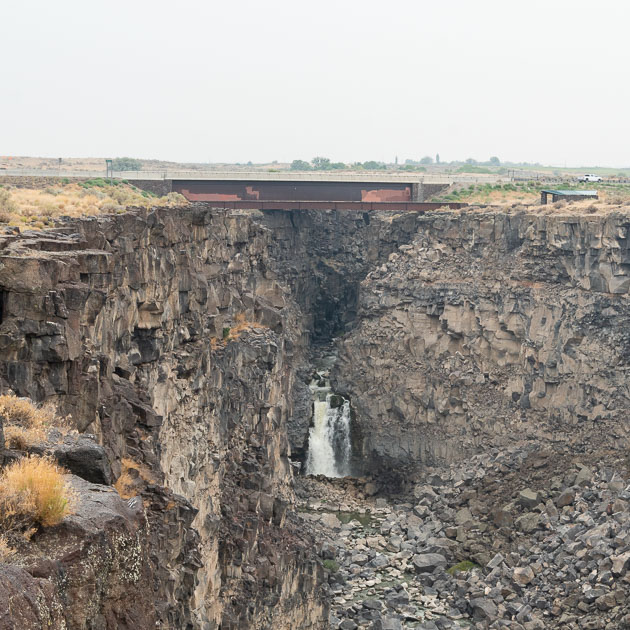
Devil’s Washbowl from a distance
Devil’s Washbowl
View from the end of the cliff
We were glad we had left for our hike early in the day. The air conditioning was a welcome treat when we returned to the car, so we opted for a drive to Murtaugh Lake—I forgot to write the name down, so I could be wrong.
If my memory is correct, this is Murtaugh Lake. Feel free to correct me if I’m wrong.
For more information on Twin Falls, Idaho, check out our blog post [add link]
Sparks and Victoria City in Nevada
Our next stop was Sparks, Nevada, to meet up with Sonia and Marv again at Virginia City for the Hot August Nights event. And as usual, we stayed at Sparks Marina RV Park.
Picnic and beach area at Sparks Marina and Lake
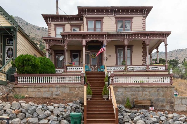
It’s always a treat to see the Victorian homes in Virginia City.
Reminds me of the Addams Family House
Cozy yellow and green cottage
Love this house with its wrap-around porch
And now for the cars.
The detail on this woody captured my attention.
Woodie, woodie, you so fine!
Updated wood dash with modern digital gauges
Put together like puzzle pieces
The beats of rock-n-roll with Lady and the Tramps
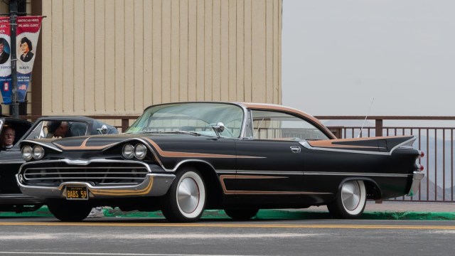
1959 Desoto
Beep, beep goes the jeep
Shelby GT 500 Mustang
Mechanic at work
Marv’s 1967 Jeep Gladiator J-3000
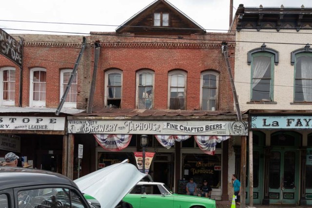
Some of the buildings are in need of repair
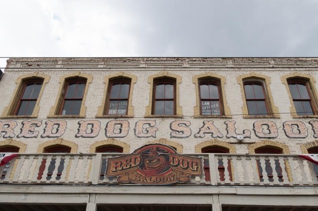
Meet us at the Red Dog Saloon
The Way it Was Museum will stir up your memories
And finally, our 2021 Summer New Mexico Tour comes to an end. We’ll be back next time with our 2021 fall tour. Hope you join us as we whirl around Southern California and Lake Havasu City, Arizona, to check in with family and friends.
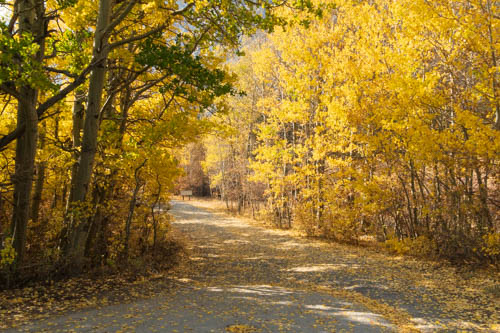
On one of our last days, we drove up to Rock Creek Canyon, which sits north of Bishop about 20 miles. Rock Creek Lake is another 10 miles through the canyon. The aspen trees sported their autumn coats, and a breeze ruffled their yellow leaves.
Sunburst shines on fall colors
The Big Meadow Campground was open for day use only. Jon would have liked to stop and fish along the creek, except he had never purchased a fishing license for 2020. So we drove on.
Entrance to Big Meadow Campground
We continued to the end of the road at the lake where we had planned to eat our lunch. Unfortunately, the road to the lake was closed, so picnic tables for eating and taking close-up photos of the lake were impossible. A few hardy anglers hiked down to try their luck. We didn’t think it was a good idea with the smoky skies.
We remembered a turnout near a western red cedar. No cars nearby, so we parked and ate our lunch while admiring the tree.
A fine specimen of a western red cedar
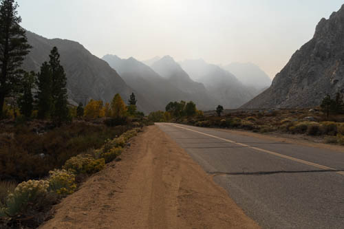
Always curious to see where roads lead, we took a detour on our way back to Bishop. We passed through farmland and ranches in Round Valley and drove by Rovana. The US Vanadium Corporation established the Rovana housing tract for its workers at the Pine Creek Mine. By 1951 there were 85 houses and another 50 added later. All the homes are still in use.
The smoke wasn’t too bad along U.S. 395, but it grew thicker as we approached the mountain. When we reached the end of the road, we could barely see the peaks.
Pine Creek Road
With the sun close to setting, we returned to the fifth-wheel to prepare for our departure the next day.
On the Road Again
We left the Eastern Sierra Tri-County Fairgrounds in Bishop on October 28, 2020. Hwy 120 through Yosemite was our usual route when the road was open. A requirement to have a reservation just to drive through kept us from taking the scenic route. A few more days on the road wouldn’t hurt and the Sparks Marina RV Park sounded like a good idea. So north on U.S. 395 we drove.
As we passed by Mono Lake, we pulled off the road to take a photo of the blue waters. From this view the tufa towers (limestone formations) weren’t visible, only the smaller forms poking out of the water near the shore. To learn more about Mono Lake and the tufas go here to see our post titled “Summer 2018 Tour – Mono Lake.”
View from west side of Mono Lake
The Bridgeport Inn looked like a good place to stop and break up our drive. The 1877 Victorian inn began as the Leavitt family home and stagecoach stop. Today the Peters family owns the property which they operate from mid-March to mid-November, providing rooms and dining for travelers and visitors to the area.
Bridgeport Inn and Restaurant
It was past noon, so we enjoyed a relaxing lunch as the only patrons in the dining room. It’s the sign of the times when the one thing on the table is hand sanitizer when you enter a restaurant. No place settings or bottles of condiments in sight. The wait staff delivers those items after you order.
Bridgeport Inn Dining Room
Kitty corner from the inn stands the 1881 Mono County Courthouse, another example of Victorian architecture in town, which is still in use today.
Mono County Courthouse
Sparks, Nevada
We weren’t in the mood to do any sightseeing while in Sparks. Instead, we hung around the trailer and walked to the marina to check the construction progress since our last visit. The first thing we noticed was the view out the fifth wheel’s back window. Here is what it looked like during our 2017 stay.
View from our site at Sparks Marina RV Park in 2017
And here is the view in October 2020.
View from our site at Sparks Marina RV Park in 2020
Another notable change was an abandoned building down and across the street from the RV park. The photo below shows the corner in 2016.
Southwest corner of E. Lincoln Way and Harbor Cove Dr. in 2016
In the October 2020 photo, the abandoned project vanished and luxury apartments sprouted in its place.
Waterfront at the Marina Apartments 375 Harbor Cove Dr.
New construction also appeared along the lake’s shoreline. In 2017, the blue and white building in the photo below was mixed use with retail and businesses on the bottom floor and condos or apartments on the upper floors. There were a few businesses that made a go of it, others were not so lucky.
Shoreline development at Sparks Marina Park Lake
And now the Waterfront Apartments dwarf the small blue building (on the right in the photo below). The once blue building was undergoing a facelift, a promise of better times ahead for the property.
Additional shoreline development
It was sad to see that our view out the back window was a three-story apartment building. Yet I understand the need for housing in Sparks. For the past twenty years, manufacturing, distribution, and technology companies have poured into the Reno/Sparks area. This made jobs plentiful, housing not so much. Reno, known as the “Biggest Little City in the World,” is not so little anymore as housing mushroomed in all directions. I guess that’s the price of progress.
Home Again
On October 30, 2020, we drove the rest of the way home. As we listened to the news, we heard that COVID-19 cases and deaths broke records daily while Trump and his campaign insisted he vanquished the virus, “It’s a beautiful thing.” One report stated once infected, you are immune for months while another report said that was not true. Nobody seemed to know what was going on.
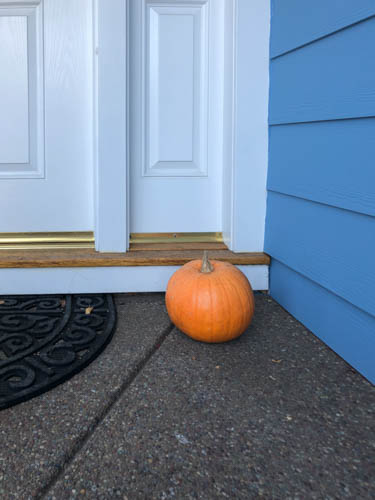
And then we pulled into our driveway and look what was waiting for us.
Welcome home and Happy Halloween
Thanks, Chris and Laura, for the homegrown pumpkin. It was just what we needed to push the bad news from our brains and focus on Halloween. Will parents take their kids out trick or treating during a pandemic? Do we want people coming to our door? Should we buy candy?
We were tired and had a lot of work to do unpacking the trailer and washing clothes, so no candy for the brave parents that let their kids dress up and beg for treats. We turned out the porch light, turned the volume low on the television, and watched a movie. If we’re home next year, we’ll pass out candy.
And with that our 2020 October COVID-19 Adventure comes to a close.
Up Next:
We have nothing more to share. Homebound describes our life since the end of October, and until we receive the vaccine and places open up, we don’t see the situation changing much.
So, I’m taking a break from posting on the blog. We’ll be back as soon as we can venture out and explore again.
Until then, stay safe.
Personal Virus and Vaccine Update
On December 3, 2020, San Francisco Bay Area health departments put us under another stay-at-home order. They released the restriction on January 25, 2021. Hooray haircut time!
Today the virus is still among us. New variants pop up weekly. Vaccines are in short supply. Distribution has been sketchy. Eligibility to receive the poke in the arm has changed more than once. Ineligible individuals are jumping the line. Appointments aren’t easy to get. More vaccine is due this week. It’s Wednesday night already. Where is it?
Jon has an appointment on Tuesday, February 9, for his vaccine. I check every day without success to procure one for myself but will keep trying.
Like everyone else out there, I can’t wait until this ordeal is behind all of us.
Welcome back to our 2020 COVID-19 Adventure after the holiday pause. I thought I could finish up the series of posts this week. Silly me. With twelve more days of travel and sightseeing, there was no way I could fit it into one post. This week we focus on Alamo, Nevada, where we made a three-night stop on our way to Bishop, California.
Before we left Utah on October 18, 2020, we stopped in Cedar City so Jon could get his second shingles shot at Walgreens and a supply of Blue DEF for the truck. The next day in Alamo, he woke up with mild reactions to the vaccine that lasted about half the day. This reduced our poking around time, which turned out okay. We found only two places to explore while in Alamo.
Extraterrestrial Highway
The Extraterrestrial Highway (Nevada SR 375) cuts off of SR 318 at the Crystal Springs Rest Area and continues for about 98 miles to US Route 6 in Warm Springs. At about half the distance sits the area of Rachael, where travelers will find the Little Al’e’inn restaurant, bar, and motel.
Crystal Springs rest area at the Y
The rest stop was a good place to eat lunch. It’s near the ghost town of Crystal Springs. Before white settlers entered the area, a Native American village used the spring. People traveling the Mormon Trail stopped there to replenish their water supplies. The thermal spring, with an 81 degree Fahrenheit temperature, still supplies water to ranches and farms up to 5 miles away.
Crystal Springs hides in the vegetation
The Alien Research Center is easy to spot from the road. Look for the giant metal alien figure on top of a hill and in front of a Quonset hut. The center is nothing more than a gift shop for the delight of tourists and alien seekers. It’s worth a stop to see all the items they sell, even if you aren’t interested in buying anything.
Alien Research Center Gift Shop
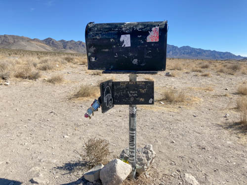
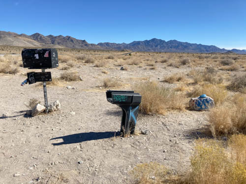
Our next landmark was the Black Mailbox. Not sure what we were looking for, we stayed alert and watched the south side of the road, trying to find the box. A bare spot up ahead caught our attention. Sure enough, there was a black mailbox out in the middle of nowhere.
The Black Mailbox. A link to Aliens from outer space?
So what is so special about the mailbox? Apparently beginning in 1973, Steve Medlin, a local rancher, used it to send and receive mail. Sixteen years later, Bob Lazar claimed the Airforce was hiding alien spacecraft that crashed in the desert near Area 51. ET-seeking enthusiasts swarmed the region and turned the mailbox into a communication device, leaving messages for Aliens and expecting return mail.
Who thought a plastic mailbox was a good idea?
Since then, visitors shot up the mailbox. It was replaced with a white box. Someone stole the white box, and it was replaced, then it was vandalized and replaced again. It appears that Mr. Medlin long ago gave up using the mailbox as his own.
Random snacks, rocks, and cans left for the Aliens?
You’d think we would have been disappointed by what we found. Not so. We had no expectations starting out and enjoyed the ride through the lovely desert.
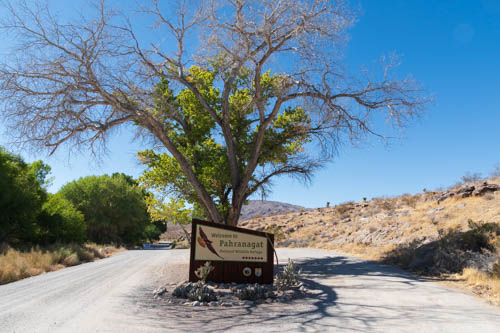
Pahranagat National Wildlife Refuge
The next day we visited The Pahranagat National Wildlife Refuge, which gave us an opportunity for an easy hike. Along a creek, we enjoyed the abundant flora and fauna along the way.
The Pahranagat Visitor Center was closed
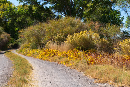
A dike in the Riparian Habitat
Thousands of migratory birds and endangered species use the refuge as a waypoint on the Pacific Flyway. The refuge includes three distinct habitats that provide rest, food, and nesting spots for the traveling birds.
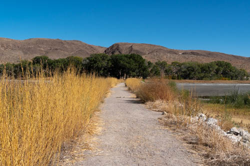
The trail connects the Upper and Lower Lakes
Cottonwood and willow trees grow at the lake shores and springs, inviting birds to nest and feed. Meadows and grasses attract rodents, reptiles, and small mammals that find shelter and food in the desert uplands. Coyotes, raptors, and roadrunners find plenty of prey to satisfy their hunger in all three habitats.
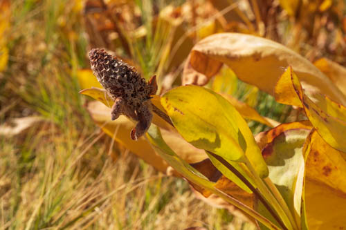
Yerba Mansa
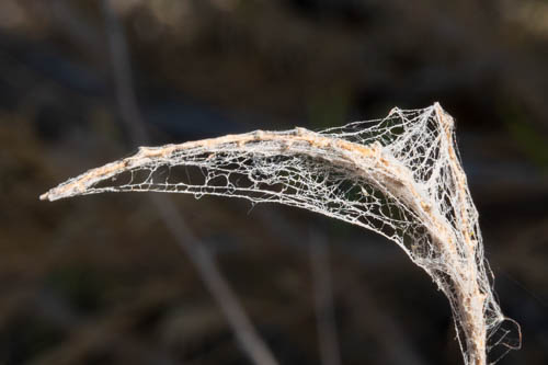
Spider’s web?
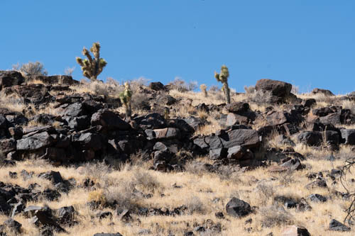
The Desert Uplands portion of the refuge contains lava rock hills and yucca trees and other cactus.
Lava Rock Hill in the Desert Uplands
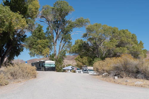
None of the fifteen free primitive camping sites were available. The sites are spaced along the east shore of Upper Lake. Good luck finding a spot. There were none when we were there. And come prepared because there is no electricity, water, or sewer facilities, only vault toilets. Many of the sites can accommodate RVs or multiple tents. The campground below was a cluster of campsites at the end of the lake.
A campground cul-de-sac
Seasonal boating, fishing, and hunting are available. Or enjoy guided walks and wildlife observation at Pahranagat.
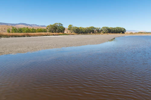
Upper Lake
Trail across Upper Lake
These little birds (finches?) did not want to pose. They preferred flitting back and forth.
There may be more to Alamo, Nevada, than what we found during our three nights there, but we were ready to move on.
Up next is our 7-day stop in Bishop, California, which served as our base camp to see Manzanar National Historic Site, Ancient Bristlecone Pine Forest, and other locations.