McDonald Observatory near Fort Davis, Texas

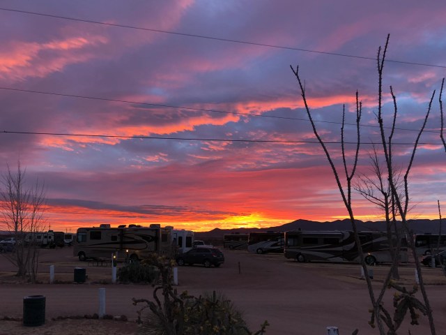
On our way to see the George H. W. Bush Library and Museum in College Station, Texas, we made a short detour through Fort Davis, Texas, with the goal of seeing the McDonald Observatory. The Twilight and Star Party programs were sold out so we signed up for the 2:00 p.m. guided tour and solar viewing. After the hour and a half drive and a quick set up at McMillen’s RV Park, we were off to see the show.

IMG_6228
McDonald Observatory Visitor Center

McDonald Observatory is part of the University of Texas in Austin and open to the public daily for guided tours and solar viewing. Star Parties and Twilight programs are offered on Tuesday, Friday, and Saturday night when visitors can observe constellations and celestial objects through a number of telescopes in the Rebecca Gale Telescope Park.

The quick meal we ate at the StarDate Cafe was surprisingly good. While we waited for the tour to begin we wandered around outside and enjoyed the view.

IMG_6230
Patio Outside the StarDate Cafe
IMG_1706
View of Hobby-Eberly Telescope from Visitor Center

The tour started with a lecture in an auditorium. The tour guide who gave the lecture talked so fast using stats and terminology beyond my comprehension that Jon had to nudge me before I fell asleep. It reminded me of being in a lecture hall in college. I wanted my notebook and pen to take notes and stay awake. The guide included views of solar activity from different locations around the world. Too bad the sun did not cooperate by displaying its spectacular solar flares. Although the sun activity was relatively calm, it was still interesting to see the views on the screen.

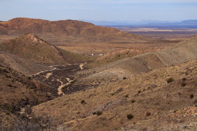
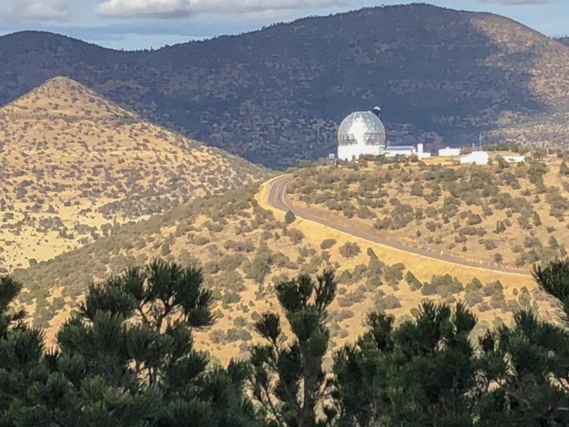
Mount Locke’s summit at an elevation of 6,791 has some of the darkest night skies making it an ideal location for monitoring celestial objects. The valley below is at an elevation of 5,280 feet.

IMG_1692
View from Mount Locke

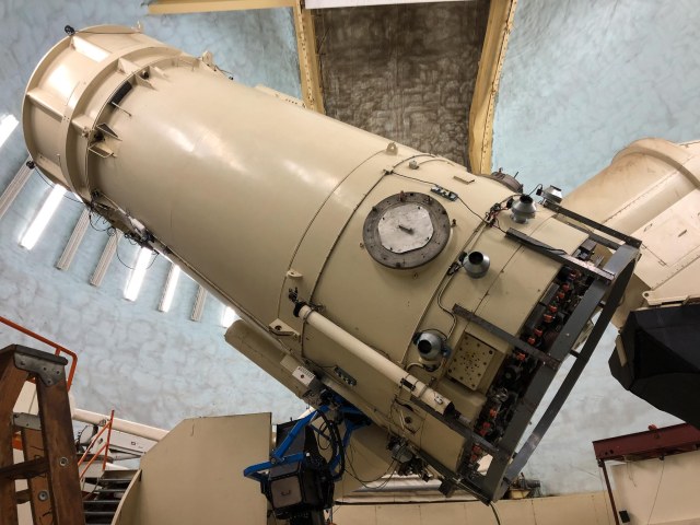
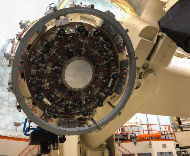
After the lecture, we all hopped in our vehicles and drove to the 107-inch Harlan J. Smith Telescope (constructed in 1968 by Westinghouse for about $5 million). The fresh air and climb up 70 steps to the top floor swept my drowsiness away.

While there, the tour guide explained the various components of the telescope, and how it was constructed. Then he showed how the top part of the building turned on steel wheels on a track rather than tires. Tires would not work for this telescope that weighs 160 tons.

IMG_1698
Shannon the Tour Guide Explains the Telescope Components

Climbing up a ladder to view the sky through an eyepiece is not needed for this telescope. The view is transmitted to a computer and displayed on a monitor. The computer also collects data used by astronomers for their research.

IMG_1694
Telescope Tube

The Smith Telescope has been used to study “the compositions of stars, the motions of galaxies, and to search for planets around other stars in our galaxy,” so says the observatory’s website.

IMG_1697
Where the Primary Mirror is Contained

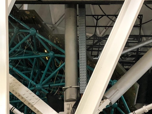
We then toured the Hobby-Eberly Telescope. The 11-meter (433-inch) mirror “is one of the largest optical telescopes designed for spectroscopy, the decoding of light from stars and galaxies to study their properties.”

IMG_E1716
Hobby-Eberly Telescope

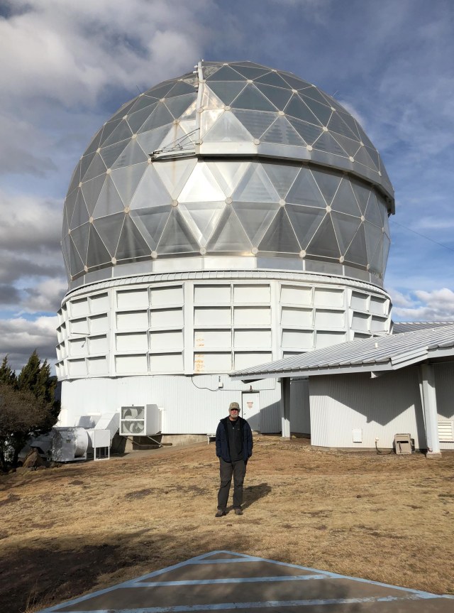
The mirror is built in a honeycomb consisting of 91 hexagonal mirrors requiring each mirror to align exactly to form a reflecting surface. This telescope is currently the third largest in the world. Although the mirror segments form a reflecting surface of 11 by 10 meters, only 9.2 meters are used at any given time. Three instruments are used with the telescope: The Marcario Low-Resolution Spectrographs, a Medium-Resolution Spectrograph, and a High-Resolution Spectrograph.

IMG_1711
The Green Pipes Support the Hexagonal Mirrors

Other telescopes at the observatory include the Otto Struve Telescope (completed in 1938 and used to discover Uranus’ fifth moon Miranda, Neptune’s second largest moon Nereid. It was also used in the discovery of carbon dioxide in Mars’s atmosphere and methane in Saturn’s giant moon Titan’s atmosphere.  The 0.8-meter Telescope (the smallest telescope at McDonald Observatory) is used for large search and survey projects, and the 0.9-meter Telescope, built in 1956, is used during the Special Viewing Nights.

For more information regarding the McDonald Observatory visit the website here. Plan ahead and make reservations for one of the Star Party events. They sound like fun.

Safe Travels


Van Horn, Texas, and Guadalupe Mountains National Monument

Day 18 Thursday, February 15, 2018, we left Willcox, Arizona, for Van Horn, Texas, for a two-night stay at Van Horn RV Park. The rain decreased around Las Cruces, and by the time we reached Van Horn, it had stopped. Plenty of cloud cover and windy but not too strong. A congregation of doves had settled at the RV park, waking us each morning with their cooing. Plenty of cholla had been planted around the park along with a few trees and the surrounding area consisted of dried grass. The next morning, nature treated us to the most amazing sunrise colors I have ever seen.

20180216-IMG_1677

We headed out to the Clark Hotel Museum only to find a closed sign and thought that perhaps it would be open later.

Clark Hotel Museum

Off to Hotel El Capitan to take photos and a drive up and down the main street to snap pics of other buildings, which are great examples of mid-century architecture.

Hotel El Capitan

Hotel El Capitan, designed by Henry Trost and built by McKee Construction Company, operated from 1930 into the late 1960s.

Front Courtyard of Hotel El Capitan
Entryway to El Capitan Hotel

The hotel was converted into the Van Horn State Bank in 1973. All of the original bathrooms were removed during the conversion.

Hotel El Capitan Lobby

Lana and Joe Duncan purchased the property in 2007 and restored the hotel replacing all the plumbing and electricity. I think the Duncan’s did a great job in bringing back the rustic look of the hotel.

Sitting Area Next to Lobby

Guests can now reserve one of the forty-nine rooms with private baths, order a cocktail at the bar, and enjoy a meal at the restaurant.

Gopher Hole Bar

We stopped by the museum again, but the closed sign was still there so we drove up and down the main street to find other restored buildings.

Magnolia Station
Raul’s Diesel

Another cruise by the museum that was still closed required us to find something else to do. Let’s drive to Guadalupe Mountains National Park. Maybe we could find a hike. But first, we had to have lunch. No telling if there were any restaurants near the park. In business since 1959, Chuy’s looked popular with all the cars and trucks out front so we gave it a try.

Chuy’s Restaurant

Football fans might recognize the name on the sign and on the bus on the mural inside. Apparently, John Madden stopped at Chuy’s on a Monday night in 1987 to enjoy a meal while he watched a football game on the television.

Portion of a Mural inside Chuy’s

So impressed with the restaurant, Madden wrote flattering articles about it and named it an All Madden Haul of Fame. He continued to visit the restaurant every year always ordering the John Madden Chicken Picado No. 21.

With our bellies full, we were off to see the Guadalupe Mountains. Overcast skies and cold winds did not prevent us from braving the elements and enjoying the nature hike near the visitor center. As visitors enter the park, El Capitan is hard to miss as it rises to 8,085 feet.

El Capitan Peak

The Guadalupe Mountains National Park, established September 30, 1972, is located where erosion has exposed a portion of a Permian (251 to 299 million years ago) fossil reef that includes Carlsbad Caverns National Park to the north and extends to The City of Carlsbad, New Mexico. Other exposed areas of the reef can be seen in the Apache Mountains near Van Horn, Texas,  to the south and the Glass Mountains near Alpine, Texas, to the southeast.

Guadalupe Mountains National Park

The park is also home to four of the highest peaks in Texas. Guadalupe Peak tops out at 8,751 feet. The fourth peak is Bartlett at 8,508 feet.

Views of Canyon and Peaks from Trail

Archaeologists have discovered evidence that suggests humans have inhabited the mountains on and off for the past 10,000 years. More recent history of the people who called Guadalupe their home, begins with the Mescalero Apaches, which viewed the area as their last stronghold after Comanches drove them from the plains.

Jon checks out an information sign

The Buffalo Soldiers, enduring significant hardships and prejudice, entered the area to fight the Mescaleros and protect the settlers. They also were instrumental in exploring and mapping the region.

Manzanita

After the cavalry and Buffalo Soldiers had driven the Mescalero Apaches from the Guadalupes, farmers and ranchers entered the area. Most of them failed. Three families survived and worked their property for decades until Judge J.C. Hunter owned most of what became the Guadalupe Mountains National Park. Hunter’s son sold the land to the National Park Service for $22 per acre after his father’s death.

Ruins of Pinery Station used by Celerity stagecoaches for eleven months from 1858 to 1859.

To learn more about the geology, people, and other features of the Guadalupe Mountains, visit the NPS site.

Alligator Juniper

There is so much to explore, we’d like to make it back to the Guadalupe Mountains someday when it is warmer. There are spaces for RVs in what looks like a converted parking lot, which would be just fine for a couple of nights.

Coming up next is our tour of George H. W. Bush Library and Museum. After visiting the Lyndon Baines Johnson Library and Museum in 2016, we have added other presidential libraries to our list of places to see. Time to see the two Bush libraries.

Safe Travels

Willcox, Arizona

Day 15 of our 2018 Winter Tour took us to Willcox, Arizona. Our goal was to see Fort Bowie National Historic Site, another place we had seen while passing through the area on our way to somewhere else. It smelled like rain when we left Gila Bend, gusty winds and thick sandstorms pelted our rig through Casa Grande. The clouds finally cleared by the time we hit Tucson, but the wind stayed with us all the way to Willcox, finally dying down around 7:00 p.m.

The groves of pecan and pistachio trees in this part of Arizona always surprise me. After traveling miles with only the desert landscape to gaze at, acres of trees pop up like a mirage. We drove through Pistachio Alley on our way to and from Fort Bowie National Historic Site Trailhead. The trees with their bare limbs don’t look like much this time of year, but I bet they are majestic covered in leaves.

IMG_6138
Pistachio Alley

Fort Bowie was named in honor of Colonel George Washington Bowie commander of the 5th Regiment, California Volunteer Infantry, who first established the fort. The trailhead can be reached through either the town of Willcox or the town of Bowie. We selected the Bowie route to avoid what I gathered was a 10-mile drive on a graded dirt road over the Apache Pass. Going through Bowie, there is only about 1 mile of the dirt road.

IMG_6136
Fort Bowie Trailhead

Don’t expect to drive a car up to a visitor center at Fort Bowie. (Accessible travel can be arranged). A 1.5-mile hike to the ruins meanders up and down hills, through a valley, alongside a spring, and past a cemetery. Information signs reveal the historic significance of the ruins along the way.

IMG_6070
Creek Crossing at Start of Trail

We took our time stopping at the ruins, reading the information signs, taking pictures, and wondering how it must have been riding a stagecoach through the rugged land.

The rocks in the photo below outline the spot where a cabin once stood. A local prospector and well digger, Jesse L. Millsap, lived in the cabin, according to his nephew who visited his uncle in a Model-T Ford with his father.

IMG_6072
Millsap Cabin Ruin

It was a pleasure walking along with only the sounds of nature surrounding us. Without the noise of a freeway, trains, and airplanes, it was like experiencing what someone during the 1880s might have experienced. Standing near the ruins of the Stage Station brought the scene to life.

IMG_6079
Stage Station Ruin Where The Butterfield Overland Mail Stopped to Exchange Mules and Rest

Imagine 6 – 8 foot-high walls surrounding a kitchen-dining room where stagehands and passengers ate a meal of bread, coffee, meat, and beans for fifty cents and rooms where guests might rest while waiting for the stagecoach to continue its route. Also enclosed within the walls was a storage room for feed and weapons and a corral for mules.

IMG_6082
Stage Station Ruin

One of the biggest events that occurred in the area was the Bascom Affair. On February 4, 1861, Lt. George Bascom gathered with 54 of his men on a mission to find Cochise, the principal chief of the Chokonen band of the Chiricahua Apache. Bascom believed Cochise and his band kidnapped a boy and stole livestock and he was intent to recover both the boy and the livestock. The problem was Cochise and his band did not take the boy or the livestock and was insulted over the accusation.

The conflict lasted for sixteen days with both Indians and soldiers capturing hostages and executing them in retaliation. For twelve years tensions between the two groups continued until President U.S. Grant sent General Oliver O. Howard to join army scout Thomas Jeffords to make peace with Cochise.

IMG_6080
Location Where Bascom Unsuccessfully Pressed Cochise to Return a Kidnapped Boy and Livestock

The Post Cemetery predates Fort Bowie when soldiers of the California Column were interred there in 1862. Other graves include military dependents, civilian employees, emigrants, mail carriers, and three Apache children including one of Geronimo’s sons.

IMG_6085
Little Robe Possibly Died from Dysentery While in Custody of Soldiers Along with Other Geronimo Family Members

The ruin in the photo below is of a late 19th-century adobe building, which housed the Chiricahua Apache Indian Agency in 1873-77. Based on an archeology study conducted in 1984,  the building contained fireplaces, three rooms, and a wooden floor. A porch may have occupied the front of the building along with corrals at the back of the building for holding agency livestock. Adobe plaster covers and stabilizes the walls exposed by the archeologists.

IMG_6088

When Cochise died in 1874, he left a band divided in leadership and conduct. Some Apaches lingered on the reservation while others left to plunder Mexican Settlements.  U.S. Indian Agent Thomas Jeffords governed the remaining 900 Chiricahua Apaches at the Chiricahua Apache Indian Agency in 1875-76.

In June 1876, the government removed Jeffords and moved 325 Apaches northward to the San Carlos Reservation. Many escaped and fled to distant sanctuaries to renew hostilities for another decade.

Imagine a camp of several thatched wickiups like the one in the photo below. Clustered together but hidden for safety, camp life continued as it had for hundreds of years.  Men rode off to hunt for game while women harvested crops, prepared food, and cared for the children. The freshwater spring and other resources in the surrounding area supported hundreds of Chiricahua during the winter and spring seasons.

IMG_6096
Wikiup Hut and Ramada

A unique feature located in Apache Pass, and a cause of many conflicts, is a freshwater spring that flows from a geological fault. Native Americans relied on the water long before the emigrants and soldiers arrived on the scene. Eventually, the Chiricahua were driven away from their home.

IMG_6099
Apache Spring

The walk to the ruins was not strenuous, but we were glad to have plenty of water and a snack with us. It is also a good idea to take along a sweater or light jacket, depending on the time of year, in case the weather conditions shift.

The steps up to the big porch at the visitor center and a comfortable bench where I could rest for a few minutes was a welcome sight. Inside the building, are a small museum and the typical national park T-shirts, hats, books, and junior ranger paraphernalia offered for sale.

IMG_6112
Long View of Fort Bowie Ruins
IMG_6105
Fort Bowie Ruins
IMG_6101
Non-commissioned Staff Officer’s Quarters

We followed the docent advice and took the return trail back to the parking lot. Although the steep incline up a hill behind the visitor center was intimidating, switchbacks and flat stretches made the descent easier.

IMG_6120
Return Trail to Parking Lot

The best part was the spectacular views of not only the fort ruins but also the agricultural zones, valleys, and cities off in the distance.

IMG_6121
Views from Atop the Hill

We enjoyed our hike to the Fort Bowie ruins and wouldn’t mind returning some day during a prettier time of year. I’d like to see the pistachio and pecan trees dressed in their leaves and the ocotillo in bloom. Next time we’ll carry a full lunch in our backpack instead of the measly snacks we had packed.

Keeping with our 250 – 400 miles a day, Van Horn seemed like the next logical place to stop as we headed into Texas.

Gila Bend and Ajo, Arizona

We left Monday, February 5, 2018, with San Diego in the rearview mirrors and the GPS pointed toward Arizona’s Gila Bend KOA. Along Interstate 8, we drove through hills populated with huge boulders, similar to what we saw at Jumbo Rocks in Joshua Tree National Park. The hills gave way to agricultural areas in the valleys. One field contained sheep clustered together in small groups as if they were in breakout sessions at a conference.

We made a pit stop at the multi-directional Sand Hills Rest Area located in the median and accessed from the fast lane. A group of ATVs on the sand hills caught my attention.

IMG_5942
Imperial Sand Dunes

We lucked out getting reservations for a week during this trip at Gila Bend KOA when someone had to delay his arrival. The owners recently completed a two-year renovation project that has enticed other winter visitors to this location, filling the park on most nights.  We ended our day sitting out under the awning, sipping beers, munching chips and salsa, and enjoying the amazing sunset and calm winds.

IMG_6059
Gila Bend Sunset

With the park so full, I expected a noisy morning. However, the loudest noises came from the cooing doves and the clicking hummingbirds that serenaded us throughout the day. An occasional boom and shake of the earth from air-to-ground bombing practice at the Barry M. Goldwater Air Force Range and a far-off freight train had little effect on the sounds of nature.

After two days relaxing and catching up on the wash and house cleaning duties, it was time to venture out. Here are a few places in and around Gila Bend that we managed to see.

Big Horn Station

Big Horn Station sits twenty miles east of Gila Bend on Interstate 8. We found a closed gate across the road with a chain in place, but no lock prevented our access to the property.

IMG_5962
Big Horn Station
IMG_5949
Big Horn Station

The Bender family established the station in the mid-1920s and became a stopping point for weary travelers between Casa Grande and Gila Bend on what once was Highway 84.

IMG_5953
Big Horn Station and Oil Rig

A. O. Bender and his son A. L. Bender made their living in the ranching industry, diversifying interests by selling gas, food, and other items to visitors.

IMG_5955
Cattle Ramp

The property is now in the hands of BLM who has partially restored the station and plans to add interpretive signs that will tell the history of the property and the people who called the station their home.

IMG_5961
Saguaro Skeleton

Sofia’s

The bright colors on the building that houses Sofia’s enticed us to give it a try.

IMG_5964
Sofia’s Mexican Food

The 6-pack with three tacos and three enchiladas was the perfect sized lunch-for-two. The enchilada sauce infused with a mild spicy flavor was one of the best I ever tasted. Cleanliness is a priority at Sofia’s. Not a speck of dust coated the windowsills and even the ceiling air vents sparkled.

Gila Bend Visitor Center and Museum

The visitor center and museum found a clever way to draw travelers to visit. Geocaches point to various pieces of information or artifacts to attract searchers to the location. For the hour we were there, four groups of people came in on the hunt to find their next cache. The lady onsite even helped some of the visitors find the few obscure items. The museum contains several display cases of artifacts and small dioramas that depict the town’s early history. It’s worth a stop to visit for an hour or so.

9/11 Memorial Park

The 9/11 Memorial Park is the location of a 4,000-pound steel beam salvaged from the New York Twin Towers Ground Zero site. A concrete marquee nearby is engraved with names of men and women who gave their lives and service in the military.

IMG_5968
Gila Bend 9/11 Memorial Park
IMG_5970
Twin Tower Steel Beam
IMG_5971
Close Up of Steel Beam

The Rest of the Town

Once a thriving community, Gila Bend has experienced economic difficulties. There are plenty for-lease buildings available for enterprising individuals who are considering starting or bringing a business to town.

IMG_5976
Stout’s Hotel “The Jewel of the Desert” Architect: Henry C. Trost Built: 1927 – 1929
IMG_5980
This Building Looks Perfect for a Craft Beer Pub 

For grocery shopping, there is a Carniceria, Family Dollar, and Dollar General. The one food market that was in town remains closed, although, the Watermill Express kiosk does a brisk business.

IMG_5978
Food Market is Closed. Drive Up to Fill Water Jugs.

A Circle K was close to completion with five or six pump lanes and a large building that looks like it will hold more than snack items and drinks. Perhaps this is a sign the town will soon experience an uptick in its economy.

Ajo, Arizona

The Ajo visitor center had a historic map with descriptions of various sites along a walking tour.

IMG_5981
Ajo Visitor Center
IMG_5983
Ajo Plaza View From Visitor Center

On the tour, we saw the Ajo Copper News building,

IMG_5988
Ajo Copper News Building. Bookstore and Printing Also Inside.

Then the Immaculate Conception Catholic Church built in 1925 in the Spanish Colonial Revival style came next. Many houses built in a similar fashion surrounded the church.

IMG_6013
Immaculate Conception Catholic Church

Also referred to as territorial houses, the most notable feature of this style is the clean horizontal lines.

IMG_5999
One of Many Territorial Houses

Artist Alley was an interesting place with its bright colorful paintings.

Our server at Estrella Restaurant & Bar christened me Miss Picky Pants for asking so many questions about the menu.

IMG_6019
Estrella Restaurant & Bar

I only wanted to know about the ingredients in the paninis in case I needed to break out the Zantac. My veggie sandwich turned out yummy (and easy on the tummy) and Jon’s ½-lb. cheeseburger was enough food for two people to eat. We washed our meals down with Arnold Palmers that were not overly sweet.

IMG_6018
Estrella Bar

The Ajo Museum and Historical Society is housed in an old Catholic church and consists of period household items, military pieces, numerous documents including school yearbooks, various historical newspaper articles, and much more.

IMG_6045
Ajo Museum and Historical Society

The docent, Louie Walters introduced himself as a retired mathematics teacher who has lived in Ajo since the 1960s.

IMG_6038
Entrance to Ajo Museum and Historical Society

He told us that Native Americans, Spaniards, and Americans all extracted minerals from Ajo’s rich ore deposits, and how the copper mining company, New Cornelia Branch of Phelps Dodge, and the town of Ajo was established and developed in the early 1900s.

IMG_6034
The Wonder of Copper Poster

He also used visual aids to show where Mexican Town and Indian Town had been located before the copper mining pit expansion encroached on the communities.

IMG_6028
Display in Ajo Museum

The company did compensate the people to leave their homes.

IMG_6039
Open 24 Hours. How Convenient.

The copper mine pit overlook was a bit disappointing. The visitor center was closed by the time we left the museum, but I don’t think it would have made much difference. The view would still have been through a fence.

IMG_6044
Copper Mine Pit and Spring Fed Ajo Lake

Our week was up and time to move on. Willcox, Arizona was our next stop so we could take a look at Fort Bowie National Historic Site, a place we had driven past two years in a row on our way to and from other places.

Safe Travels