2014 Carlon Falls and Yosemite

Our 2014 adventures continued with a trip to Yosemite National Park for a few days in September. Our son and his better half met us there for some hiking and fishing. Yosemite, like most of the nation’s parks, requires reservations several months in advance. Luckily, Yosemite Lakes RV Resort had space for us. Although it was only 5.5 miles from the entrance, it was another 19 minutes to reach the valley.

View from our campsite at Yosemite Lakes RV Resort

Carlon Falls

We chose the Carlon Falls hike as our first activity. The trail to the falls is 2.8 miles roundtrip from the trailhead and travels through Yosemite National Park Wilderness. Six years after the August 2013 Rim Fire, the park’s website still warns of danger trekking through the burn area. Loose and falling rocks, and trees weakened from the fire and drought, could cause injury or even death to unsuspecting hikers.

Approaching the Yosemite National Park Wilderness gate on the Carlon Falls trail

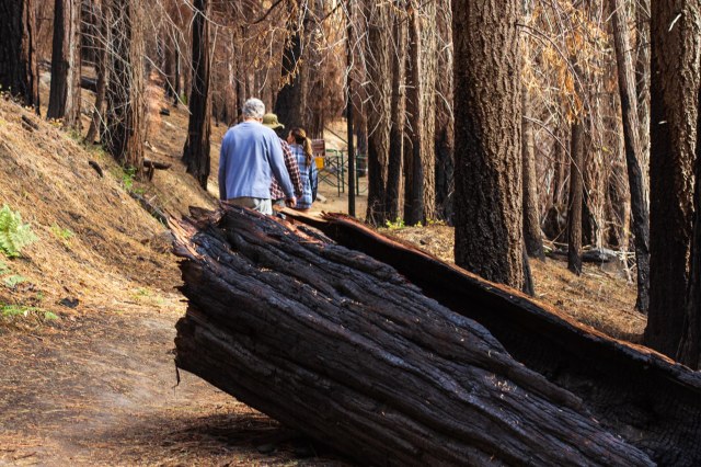
In 2014, we found the trail well marked as we passed through burned-out logs and fire scared tree trunks and then we entered a lush green forest and underbrush. The south fork of the Tuolumne River meandered through the rocks and vegetation as it made its way toward the main river.

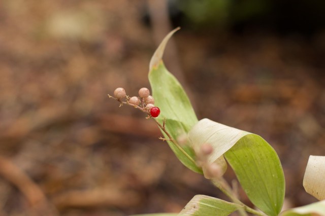
One year after the 2013 fire, these little seedlings had sprouted among the charcoal debris. I wonder if they survived the remaining drought and harsh conditions.

Little sprouts vying for survival in the ashes

The trail seemed to disappear just short of the falls, blocked by huge boulders.

The holes in the granite reveal a powerful river compared to what we saw.
Kevin navigates the boulders with ease
No, this isn’t an ad for Arrowhead water, just a cute pick of Bailey
JT sizes up a fish he saw

I wasn’t quite as quick to scramble over the impediments as the others, especially with my pack strapped to my back and a camera slung around my neck. I’m not so sure it was worth it given our visit was in the fall during the middle of what turned out to be a seven-year drought.

Carlon Falls

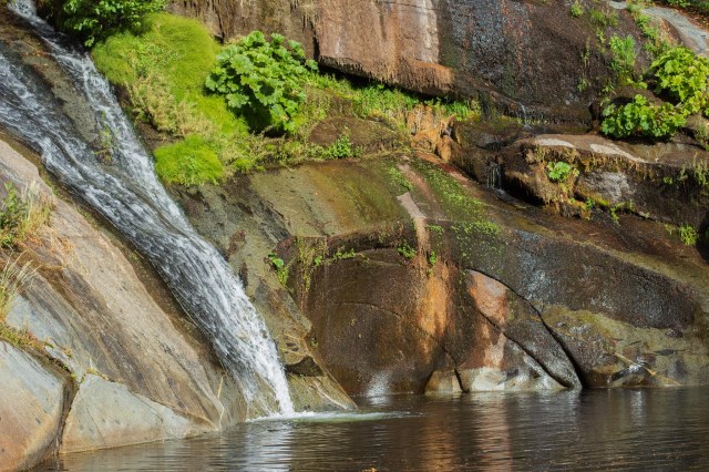
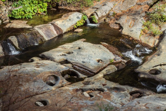
Images of the falls online show a wall of water rushing over the granite wall and mist rising from the pool. During our visit, it was not such a spectacular sight due to the drought, but it was peaceful back there. With birds flitting among the trees, squirrels scampering about, and the water tumbling over the granite wall and gently splashing into the pond, it was the perfect respite after the boulders.

Fishing

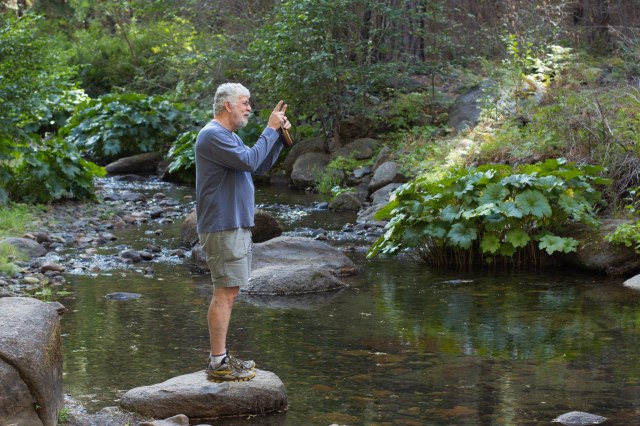
Fishing is not allowed in the Park, but at the Carlon Falls parking and picnic area, there is access to the south fork of the Tuolumne River. The gang grabbed their gear, baited up, and stood back to wait for the fish to come and take a taste of whatever goodies covered up the hook.

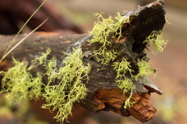
Fishing is not my thing. I just can’t bring myself to hurt the rainbow-striped critters, so off I trotted up and down the stream looking for interesting artifacts to photograph. Here are a few things that caught my eye.

Obviously, the water runs deep enough at times to erode the soil from these tree roots
A granite wall keeps the water in check
Layers upon layers upon layers of graffiti, modern-day petroglyphs, on the bridge support
Raindrops cling to branches after a short rain
Poisonous or edible? I’ll leave it for the bears.
Lichen growing on a downed tree limb
A bridge over peaceful waters
Watch your step across the reflecting pool
Let’s see. One, two, three, . . . Perhaps 30 years old?

When I returned from my photo walk, the gang had caught enough trout for a small dinner feast. I may not like to fish, but I sure do like to eat them.

Yum, dinner!

Yosemite

Tunnel View Overlook

On June 30, 1864, President Abraham Lincoln signed a bill creating the Yosemite Grant, which was turned over to California to operate. The area surrounding the grant became Yosemite National Park in 1890.

From left, Jon Todd (my hubby), Bailey Bishop (Kevin’s better half), and Kevin Todd (my son)

Seeing damage caused by overgrazing and other commercial activities in and near the park, John Muir, among many other conservationists, lobbied President Theodore Roosevelt to have the federal government take control of the grant and expand and protect the park. Three years later, Roosevelt signed the bill that accomplished the conservationist’s goal.

Site of meeting between Muir and Roosevelt
Jon, Bailey, and Kevin with El Capitan in the background
Half Dome, of course

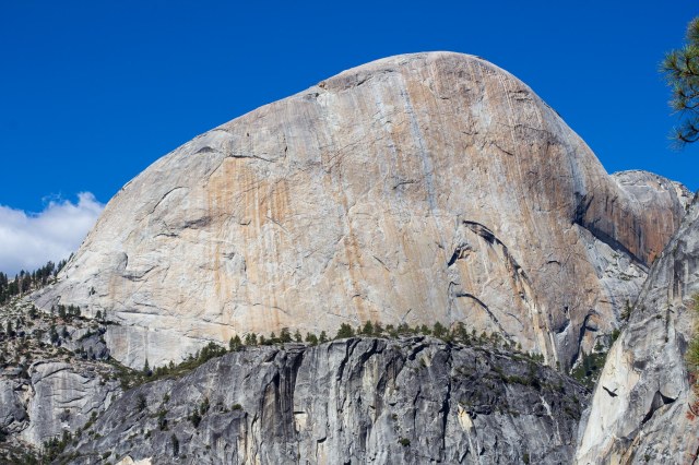
With limited time to visit Yosemite, we selected a one-way bus ride to Glacier Point and a hike down the mountain on Four Mile Trail. I was concerned my knees might falter on the 3,200′ downhill slope.

We joined the crowds along the paths and overlooks around the visitor’s center to marvel at the breathtaking views.

View from Glacier Point overlook
Half Dome in the shadows
The ancient art of marking up an object with petroglyphs and pictographs lives on in modern times
“Come on, everybody, here we go.”
Rear of Half Dome
“Look at this great pic I took.”
Way down in the valley there are roads and vehicles and buildings. At this distance, they fade into the scenery.
Never can take too many pictures of Half Dome
Nevada Falls
Gnarly tree stump
“Yes, dear. You’re so strong and handsome.”
Four Mile Trail continues around the giant granite slab
A fern finds a perch
First sign of fall

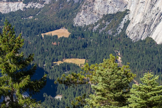
My knees held up during the hike thanks to the switchbacks that eased the descent. We all were glad to come to the end, visit the restroom, and head back to our vehicle. I’d sure like to try hiking up the trail someday.

Safe Travels

The California Lost Coast and Humboldt Redwoods State Park

A few days among the giant redwoods sounded like a good idea before we concluded our 2014 Pacific Northwest adventure. We settled in at The Ancient Redwoods RV Park where the Immortal Tree stands. The tree survived a lightning strike that removed approximately 50 feet from its height in 1908 and a flood in 1964, two recent life-threatening events that have occurred during its 950 – 1,000 years.

Immortal Tree

Lost Coast

We drove around the next day and chanced upon one of those roads that made us ask, “I wonder where that goes.” Over bumpy terrain we traveled, up hills and down hills, through small settlements in the middle of what looked like nowhere until we arrived at Shelter Cove.

Mal Coombs Park

Cape Mendocino Lighthouse located at Mal Coombs Park in Cape Mendocino attracted our attention. First lit on December 1, 1868, the US Coast Guard abandoned the building at its original location in 1948 when it installed a new beacon light on higher ground. For the next 50 years, salt spray, punishing winds and torrential rains deteriorated the lighthouse until a group of citizens gained control, restored, and installed it at Mal Coombs Park.

Cape Mendocino Lighthouse

Near the lighthouse stands a statue and marker honoring Mario Machi, a founder of Shelter Cove along with his brothers Tony and Babe. The marker states he survived the Bataan Death March and three years of captivity in World War II. How wonderful that the man was so loved the town saw fit to honor him.

Beloved founder and resident Mario Machi

Not far from the lighthouse, we found tide pools to explore.

Crashing waves not far from tide pools

The clear water made it easy to spot sea life among the shallow waters.

Clear, clear water

I almost missed seeing the crab among the pebbles, shells, and bones.

Hey, what you looking at?

This was our first experience seeing a chiton shell. Our marine biologist friend later told us chitons are common. Thanks, Ray for educating us.

Chiton shell

Another first for us was the turban snails with their colorful purple and blue shells, definitely my favorite.

Turban Snails

A mile or so up the road along the coast we stopped for a photo op, catching a little wave action and capturing flowers nestled in the grass.

Coastline
Bouquet of flowers nestled in the grass

Humboldt Redwoods State Park

We never tire of walking among the California redwood trees and the Humboldt Redwoods State Park did not disappoint. The 53,000-acre park includes 17,000 acres of old-growth coast redwoods, the tallest known tree species in the world. They average in height from 150 – 250 feet tall and can exceed 350 feet, with a diameter of 20 feet or more. The bark on a mature tree can be one foot thick.

Searching for the top

Rather than a taproot like most trees, the root system of a redwood is shallow and extends up to 100 feet outward connecting with the root systems of other trees. I once heard on a podcast that trees communicate with each other and share resources through their root systems. If one tree needs nutrients to survive, the other trees will pitch in. The trees also possess a natural resistance to fire, disease, and insects, which contributes to their long life.

Jon and Linda standing by a root

The trees can live several 100 years or even more than 2,000 years. Consequently, they are the oldest tree species in the world. High winds and flooding are the trees’ enemies.

There’s the top

A tree can reproduce when one of its seeds germinate (a rare occurrence) or when a new tree sprouts from the root of a parent or from burls. Seedlings that survive can grow more than 1 foot per year.

Hey, here I am.

Besides the old-growth forest, the park contains 250 campsites for tents and RVs 24 feet in length or shorter, 100 miles of hiking, biking, and riding trails, and the scenic 32-mile Avenue of the Giants. Driving along the Avenue of the Giants at times is like driving through a tunnel lined with the magnificent trees.

Giant ferns for a giant tree

Thanks to Henry Fairfield Osborn, John C. Merriam, and Madison Grant, who formed Save the Redwoods League in 1918. Without their perseverance and fundraising, the trees may not have survived the loggers’ axes.

Have a seat, or maybe not.

Dyerville Overlook

On our way back to our temporary home, we stopped at the Dyerville Overlook near Garberville. We would have expected more water running in the Eel River during May. A little research revealed dams and diversions limit the amount of water that flows at this location. They also maintain sufficient water to sustain fish populations during the dry season and prevent the type of flooding that occurred in 1955 that destroyed the Dyerville settlement and the one in 1964 which wiped out four other communities.

Abandoned railroad bridge

The bridge once carried Northwestern Pacific Railroad traffic between Eureka and San Francisco. Sadly, the railroad suffered the same fate as the communities destroyed by the floods. The graffiti painted train engine shown in our Eureka, California, blog post may have once rolled over the bridge in its heyday.

We started this series with the tulips in Washington, and end with a couple more flowers of a different varieties.

Yum, yum, gettin’ me some nectar
Purple flower

Fifth Wheel Dreams

Throughout our travels on this trip, we continued to find fault with our little trailer and dreamed of the Cougar fifth wheel we saw in Washington. Along our route we stopped in at a dealer in Oregon and another one in Petaluma, California. After perusing the pamphlets and climbing in and out the various styles and sizes, we made our choice. One month later, we were the proud owners of a new truck and fifth wheel, enjoying the outdoors on a shakedown cruise.

We gained elbow room in our new trailer.

Since then we have checked out the new models of all brands at the annual RV show at our local fairgrounds and during our travels. To date we have yet to find another model or size that would suit us any better. After five years we are satisfied with our purchase. Now if we can get back on the road to enjoy it, we would be super happy campers. Soon. Hopefully, soon.

Safe Travels

Eureka, California, Here We Come

We continue our 2014 Pacific Northwest Tour with a quick stop in Eureka, California. A hurried walk through town, taking photos of iconic Victorian homes, and more photos at the marina on Woodley Island was about all we could fit into the few hours we had to explore.

View of Carson Mansion with a raptor in the sky

The Ingomar Club, or Carson Mansion, and the Pink Lady are the first images that appear when conducting an online search for Eureka, California. So excuse me while I add my contributions to the plethora of shots that already grace the internet.

Carson Mansion and Ingomar Club

The Ingomar Club, a private social club in Eureka, has the distinction of owning the Carson Mansion. Their mission is the restoration and preservation of the mansion and the grounds. They offer fine dining and social experiences for its members. Initiation fees and membership dues are not posted on their website. If I have to call or fill out an application, I suspect their fees and dues are out of reach for my budget.

Based on the exterior, I must conclude that Ingomar Club has lived up to its mission in preserving the property. The maintenance of the high standard lumberman William Carson established in 1885 when he built the home is evident. The 19th Century Victorian architecture with all the nooks-and-grannies and decorative wood adornments must need constant care and upkeep.

I desperately wanted to peek inside. Alas, that is not possible. This is a private establishment. Members only. Not open to the public. No tours. Stand over there across the street, take your photos, and “see ya” was the message.

The Pink Lady

The Pink Lady, a Queen Anne Victorian home built in 1889 by William and Sarah Carson as a wedding present to their son Milton, is another story. After the Milton Carson family sold the home it passed through several owners. In 2014 when I took the photos, an architect used it for his office.

Since then, new owners have renovated the home as a vacation rental. It can accommodate up to 10 guests in its 4 bedrooms with 6 beds and 2.5 baths. The full baths feature claw-foot tubs. The modern kitchen includes the necessary amenities and essentials. On redwoodcoastvacationrentals.com, they advertise that you just may get a chance to dine at the Carson Mansion. What was that? Dinner at the Carson Mansion?

“Hey, Jon. Pack the bags. We’re driving to Eureka.”

“Okay, okay, Linda. Calm down already.”

Sorry, I got carried away.

Anyway, both buildings are listed on the National Register of Historic Places. The architects for both the Carson Mansion and The Pink Lady were Samuel and Joseph Cather Newsom, Newsom and Newsom Architects of San Francisco. Wait a minute. California Governor Gavin Newsom grew up in San Francisco. Could he be related? Wikipedia says no.

Unable to obtain accommodations at The Pink Lady? I imagine Carter House, Carter Cottage, and Bell Cottage have equally impressive digs for a night or two.

Carter House Inn
Bell Cottage and Carter Cottage

When visiting, don’t forget to take a stroll around Historic Downtown Eureka for more examples of Victorian-era buildings.

Oberon Grill still in business as of August 2019

Eureka boasts not one but two bookstores for a population of approximately 27,000. They probably enjoy business from students attending Humboldt State University, which is only eight miles away.

The Booklegger looks like a place to step in and browse the aisles
Eureka Books is also a thriving enterprise

I couldn’t pass up a photo of this rusted hunk of a train engine splattered with graffiti. It’s not the usual iconic photos of Eureka. I wondered if a group was planning on reviving the abandoned railroad or turn it into a museum at some point. A quick search on the internet did not reveal any plans to do unless I missed something.

Abandoned rolling stock

When a drive over to Woodley Island Marina to see Table Bluff Lighthouse is a must. Although the lighthouse stands only 35 feet tall, ships 20 miles away could see the light. This was because of the bluff’s height. The original structure was built in 1892 and the light was deactivated in 1975. The tower was moved to Woodley Island Marina in 1987.

Table Bluff Lighthouse no longer sits on a bluff

Another local iconic photo is of the sculpture The Fisherman by Dick Crane. It resides at the marina on Woodley Island.

The Fisherman by Dick Crane

As always, I wished we would have had more time to explore Eureka and Humboldt County. I find it frustrating that there is so much to see and so little time in which to see it all.

We make one more stop on our way home. Stay tuned for the Lost Coast and Humboldt Redwoods State Park.

Safe Travels


We Continue a Look Back on Our 2014 Pacific Northwest Adventure

Our 2014 Pacific Northwest adventure continued on May 6 as we headed south and a bit east toward Central Point, Oregon. We had stopped at the KOA in Central Point on our way north to Washington State. This time we planned to stay a few days so Jon could reconnect with an old friend from high school.

About 15 miles north of Grants Pass, we noticed a covered bridge near Interstate 5, so we had to stop to have a look. Covered bridges are not a common sight in our home state of California.

Grave Creek Bridge

The Grave Creek Bridge in Josephine County was built in 1929 and once carried traffic from U.S. Route 99, the Pacific Highway. In 1979 the bridge was added to the National Register of Historic Places. Closed in the late 1990s for repairs, it reopened in 2001. The 105-foot Howe truss bridge includes six Gothic windows on each side, rounded portals, and a shake roof.

Jon connected with his friend, and we enjoyed a dinner with him and his wife. They recommended the Upper Table Rock trail for a bit of exercise and a fantastic view of the Rogue Valley from the volcanic rock plateau. The clear skies and warmer weather were welcomed as we walked through the trees that towered above the trail on either side.

Upper Table Rock Trail

Wildflowers dotted the terrain here and there with their blossoms tracking the sun. Pacific Madrone trees along with California black oak, Douglas fir, and incense cedar provided shade for hikers and homes for the birds and rodents that live in the area.

Ookow wildflower
Unidentified hairy flower. Does anyone know its name?

Pacific Madrone trees

Daisy-like flower

I always find it interesting to learn about the geology of a place. The Upper and Lower Table Rocks brochure tells the story that began 7.5 million years ago when a shield volcano (similar to Kilauea and Mauna Loa in Hawaii) erupted.

Upper Table Rock plateau with basalt showing through the grass

The volcano’s lava spread over the entire valley causing the valley floor to rise 800 feet to the height of the plateaus. Over millions of years, the ancient Rogue River eroded and carved out 90 percent of the lava rock, leaving the rich valley, a few monoliths, and the two horseshoe-shaped mesas known as Table Rocks.

The Rogue Valley

As I stood back from the edge of the mesa, I tried to imagine the valley filled with lava rock. It must have looked similar to Craters of the Moon National Monument in Idaho. Then I tried to image a river flowing so powerfully to clear out the basalt. It’s the same old geological story of building up and breaking down. It makes me wonder what Craters of the Moon might look like in a few million years.

View of Lower Table Rock from Upper Table Rock

After our hike, we stopped in at the Del Rio Winery for a tasting and to see if they had a bottle of something we might enjoy.

Del Rio Winery

The tasting room is located in Gold Hill in the historic Rock Point Stage Hotel. Constructed in 1865, the hotel, as noted on their website, has quite a history of ownership.

Del Rio Vineyards

The winery offers both red and white varietals, a picnic area for visitors to use, and concerts during the summer.

Next up we continue our 2014 tour and make a stop in Eureka, California.

Safe Travels