Summer 2021 Tour Ruidoso, New Mexico, Episode 2: Billy the Kid, Fort Stanton, and Lincoln

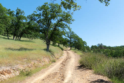
One day we took Billy the Kid Trail to Capitan, Fort Stanton, and the Village of Lincoln

Smokey Bear Historical Park

We missed seeing the Hubbard Museum, but were lucky to find the Smokey Bear Historical Park open for business in the Village of Capitan. The Historical Park contains a museum with various fire prevention displays, Smokey Bear memorabilia and trinkets to purchase, and a garden filled with native trees, plants, and flowers.

Smokey Bear memorabilia
Available for purchase
Firefighting displays
Photo of CCC crew. The first time I saw this photo, the guy leaning off the stake bed truck in the far right center drew my attention. He brought the picture to life for me.

After wandering through the museum, we headed out back to the shady garden where they buried Smokey Bear and where little plaques identify plants and trees and flowers.

Tiny cactus
Cactus bloom
Image of Smokey as a cub in the garden
Firefighter memorial
JT poses with Smokey

Here are a few Smokey Bear fun facts we learned:

  • While fighting a fire in the Capitan Mountains, a group of soldiers from Ft. Bliss, Texas, found a badly burned bear cub clinging to a charred tree on May 9, 1950.
  • Ray Bell, a New Mexico game warden, flew the injured five-pound cub to Santa Fe where veterinarian Dr. Ed Smith treated him.
  • Ray Bell’s wife and daughter, Ruth and Judy, helped nurse the cub back to health.
  • An article written by Dorothy Guck, a Lincoln County newspaper reporter, and photographs taken by Harold Walter brought national attention to the plight of Hotfoot Teddy, Smokey’s original name.
  • A formal fire prevention campaign began in 1942 by the USDA-Forest Service, adopting a bear as its symbol in 1944 and the message “Remember . . . Only YOU can prevent forest fires” in 1947.
  • Once recovered, Hotfoot Teddy became Smokey and sent to the National Zoo in Washington, D.C., becoming the “living symbol” of fire prevention.
  • The Secretary of Agriculture controls the image of Smokey, which has allowed the collection of millions in royalties for forest fire prevention education efforts, including the Junior Ranger Program.
  • Smokey had received so much fan mail by 1965 the postal service gave him zip code, just like the President of the United States.
  • Smokey Bear was buried at the historical park, as is the original 1993 Smokey Bear Balloon, which was destroyed during a flight on October 10, 2004.

The message “Remember . . . Only YOU can prevent forest fires” must have worked on me all these years because whenever I’m near a forest, those words pop into my thoughts. In April 2001, the slogan was updated to “Only You Can Prevent Forest Fires.” I think the shorter version has more punch.

Fort Stanton

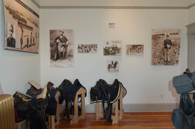
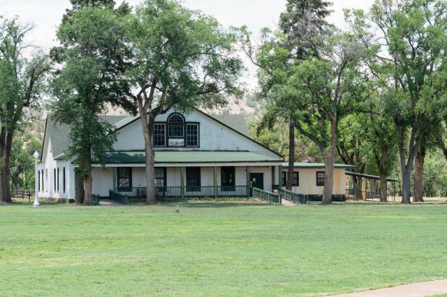
We said goodbye to Smokey and headed down the road to Fort Stanton. Fort Stanton is one of seven New Mexico Historic Sites and is managed by the Department of Cultural Affairs.

Main Museum and Visitor Center, originally constructed of local stone in 1855 and used as barracks for enlisted soldiers. Extensive remodel occurred during the hospital years and used as an administration building.

Founded as a military fort in 1855, it served a number of functions during the past 166 years including a tubercular hospital, Civilian Conservation Corps camp, state hospital, drug rehab, correctional facility, and since 2001, a living history museum.

The colors on the jackets symbolize the rank. Not sure which color goes with which rank.

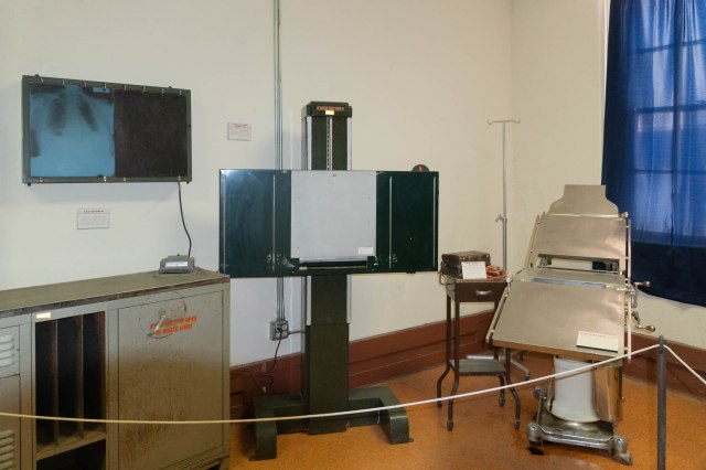
There are 25 locations or buildings surrounding or near the parade grounds, nine of which are open to the public. The open buildings we went in contained equipment and furniture of the times along with information posters and signs detailing the history and people that worked there.

Photos and historic stories
Saddle and photo room inside visitor center
Parade grounds
Originally built in 1883 as a duplex to house two officers and their families. It’s now used by the Bureau of Land Management.
Fort Stanton Marine Hospital built in 1936 for up to 85 tubercular patients. Doctors were also tubercular patients.
Period furniture and equipment occupy the hospital rooms
X-ray machine in an exam room
A dentist office.

I lost interest in the buildings when grazing horses appeared on the parade grounds, and I set out photographing them instead of browsing inside buildings. I seem to remember that hunger was also a factor that kept us from exploring the fort in more detail.

One of the grazing horses
This building, built in 1855 as a single story building, was used for Fort Administration. During hospital years, it became the amusement building, with a general store, telephone exchange, post office, and a theater.

Lincoln Historic Site

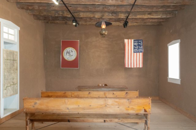
Settled in 1849, the village of Lincoln became the county seat when Lincoln County was established in 1869. Except for the paved main street, the town has preserved the look and feel from the late 1800s, with a few alterations. The site boasts 17 territorial-style adobe structures and outbuildings, 6 of which are open for touring (4 opened yearly and 2 seasonally).

Built in the 1850s, the thick walls of the Torreon (the keep) protected Spanish Americans from the Apaches. The Murphy-Dolan group stationed sharpshooters in the structure during the Lincoln County War.

So what is so special about Lincoln that earned the entire town as a New Mexico historic site designation?

The Lincoln War

In the early years of New Mexico Territory, range wars were common occurrences that pit one group of cattle ranchers against another or three or four. The Lincoln War, however, turned out to be one of the deadliest waged by both respectable and criminal types alike.

The saga is filled with a cast of characters with greed in their hearts, guns in their holsters, and in their minds, murder.

The Covento building, built in 1868 as a flat-roofed adobe building was used as a saloon, dance hall, community center, a county court, and a local parish of the Roman Catholic Church.

Instead of filling this post with a doctoral thesis on the Lincoln War, I present an extremely short synopsis.

Inside a portion shows the Covento as a courthouse.

Lawrence Murphy and James Dolan enjoyed an economic and political monopoly over the Lincoln area after procuring lucrative federal contracts to supply Fort Stanton and reservations nearby. They enjoyed the fruits of those contracts until November 1876. That’s when John Tunstall came to town with cattle rancher John Chisum and attorney Alexander McSween. They were intent on upsetting the monopoly by establishing a ranch, store, and bank to compete with Murphy-Dolan.

Additional displays tell stories about historic events or people. These panels tell the story of the Horrell War, which also resulted in numerous deaths.

Sides were drawn, gangs were formed, harassment and cattle rustling ensued, killings occurred, which led to more killings. Tunstall’s group formed the Regulators and Billy the Kid joined them. The Regulators and the Sheriff’s posse battle it out a few times and more men die.

San Juan Mission building

Then came the Battle of Lincoln. The Murphy-Dolan faction surrounded the Regulators in Lincoln on July 15, 1878. For the next three days, gunfire rang out in the town, along with a volley of taunts and shouts. The US Army troops arrived, pointed cannons at the Regulators, causing many of them to flee.

Inside the San Juan Mission building

The conflict culminated on July 19 when the Murphy-Dolan group set the McSween house on fire where McSween, two women and five children, Billy the Kid, and other Regulators were holed up. The women and children were allowed to leave, and the fighting continued until the Regulators fled. Some of them were gunned down during their escape. Billy the Kid escaped unscathed.

We missed seeing the Tunstall Store Museum as it was closed.

Not much resulted from the war other than the killing of at least nineteen men. The new governor of the territory declared amnesty for the remaining individuals involved in the war. As it turned out, the governor did not include Billy the Kid in the declaration. Sheriff Pat Garrett and his posse tracked Billy and two of his compadres, killing all of them in July 1881.

Old Dolan House. A sign out front advertises it as a B&B, yet it was closed during our visit.

One might say the person who benefited from the war was Susan McSween, Alexander McSween’s wife. She amassed a large amount of ranch holdings that averaged between 3,000 and 5,000 head of cattle and became known as the Cattle Queen of New Mexico. She died on January 3, 1931, at 85 years old.

After reading article after article and falling into research rabbit holes, I’m still debating who was respectable and who was criminal. Both sides engaged in a deadly game of tit for tat, so it’s hard to tell. Maybe the Old West definition of justice meant something totally different from how it’s defined today. Or maybe it is the same, minus all the killing. Or maybe I just have a Pollyannaish sensibility, looking for the good guy where one does not exist.

Up next: We stretch our legs on a hike, visit a ghost town, and stumble upon a surprise.

Safe Travels

Summer 2021 Tour San Diego, California Episode 3: Valle de Guadalupe, B.C., Mexico

We’re back with our last episode of San Diego, California. Lack of WiFi and data service kept us offline for several weeks. Then my laptop needed an update to connect via WiFi. Now that we’re home, we can continue with our regular blog schedule. In this episode, we visit Valle de Guadalupe, B.C. Mexico and look at the construction taking place at the old Jack Murphy Stadium.

A Wine Tasting Tour in Baja? What about COVID? We heard Mexico’s protocols were more stringent than those in the United States. They continued with social distancing and wearing of masks, whether vaccinated or not, except for drinking and eating, making us feel comfortable and safe.

On Saturday, June 12, 2021, Kevin, Bailey, Jon and I crossed the border at Tijuana as foreign pedestrians. After crossing to the Mexico side, we met Jaime, our tour guide for the day. Bailey served as our interpreter since the rest of us Gringos only spoke English.

Border Crossing in Tijuana

It was a scenic one and a half hour drive. As we passed Rosarito Beach Hotel, Jon and I laughed as we remembered the hotel when we visited in 1975 or 76. Our accommodations were not in the multi-story building we had just driven past. Instead, the “hotel” was composed of a few rows of single-story manufactured buildings with maybe four or six rooms per unit. I’m sure the bed was lumpy, the linen suspect, and unless my memory is faulty, a shared bathroom was involved. My, how things have changed over the past 47 years.

The landscape had also changed with the added freeway and toll roads and the amount of growth south of Tijuana and into Ensenada. Nothing was like we remembered.

When we turned off and headed east into Valle de Guadalupe, it was as if we were driving into Sonoma or Napa, California. Vineyards blanketed the bowl-like valley below brownish hills. One notable difference was the sparseness of paved roads. Although the main roads were paved, dirt roads usually led the way to the wineries.

Our first stop was at Sol Y Barro, which translates to sun and mud. It’s the sun and mud, or soil, that makes the wine, or so our server told us. We liked the winery for its comfortable rustic atmosphere amid the vineyard. Nothing fancy there, just good tasting wine and friendly service.

Sol Y Barro Entrance
Sol Y Barro Building
Salud
View from our table

The second stop was supposed to include lunch. When our guide pulled into the parking lot and saw five tour buses sitting there waiting for their passengers, he chose a different winery instead. That was fine with us. We weren’t ready to get up close and personal with a bunch of people we didn’t know, even if our stomachs were growling.

Our guide had arranged a tour at Baron Balch’e followed by a tasting. The winery tour guide told us about the wine-making process while escorting us through the steel vats, barrel room, and bottle room. It shocked me to learn they use egg whites (1 to 2.5 egg whites to 60 gallons of wine) during the process. The egg whites contain albumen which reduces harsh astringent tannins. I had never heard of that before.

Stainless Steel Fermentation Tanks
Our tour guide explains the process.
Barrel Room
The mural depicts the different stages of growing grapes
The Bottle Room
check out the post and ceiling in the winery gift shop
A little smooch to go with our tasting

Our final stop was at El Cielo Winery. Food at last. Was it our hunger, or was the Baja-Yucatan fusion cuisine really that delicious? I’ll give all the props to the chef at Latitude 32 for his inspired dishes. With our bellies full, we proceeded to another round of fine wine tasting and entertainment by the resident peacock that wandered through the tables and delighted the guests.

The restaurant is on the right and wine tasting on the left
Or, choose a table on the lawn and order from the Smoke Kitchen
Bailey’s iPhone captured this view from the restaurant
Step right up for stomping photos
Clink!
Wine tasting patio with fireplace
Oh, hello there.
Mr. Peacock poses with Bailey
Kevin poses with Mr. Peacock
I couldn’t resist a closeup of his shimmering colors.
Jon’s feeling no pain
Vineyard and hills
Drink up. It’s time to go

We let Jaime do the driving back to the border. We were all tired, a bit tipsy, and wanted to get home. But first we had to navigate a line to meet with the border agent and reenter the United States. Our day trip to Valle Guadalupe was a great adventure even if we were all wiped out from the wine, food, and long drive back. Next time, it would be fun to stay overnight.

San Ysidro Port of Entry

Before I wrap up the San Diego series of our Summer 2021 Tour, I want to take one last look at San Diego Stadium (also known as Jack Murphy Stadium (1981-1996), Qualcomm (1997-2017), and SDCCU (2018-2020). The stadium sat for decades at the foot of Mission Village Dr. on Friars Road where the Chargers played their first game on August 20, 1967.

Stadium gate

Instead of a concrete structure, we saw piles of dirt, work trucks, and equipment preparing the acreage for its new life.

Piles of dirt have replaced the concrete structure

Although the stadium is gone, college football, other sports, and events will continue at the site when San Diego State University completes the new stadium. Besides a new stadium, the $3.5 billion project will include housing, office and retail, hotels, 80 acres of parks and open space, and a 34-acre river park on city property. These amenities are expected to roll out over the next 8-10 years.

The stadium trolley station is temporarily closed until construction completion.

It was sad to look at the rubble that was once the stadium and parking lot. However, after learning about all that will replace the aging Jack Murphy Stadium, I can see the benefit of letting go of the past and looking toward the future.

Cranes lift steel girders in place on a new building

I finished taking photos of the construction site, and then we went to The Original Pancake House for breakfast. We arrived early enough so that we only had about a 10-minute wait for a table. My mouth waters just thinking about the apple waffle with apple syrup I had and Jon’s pecan pancakes and side of sausage looked pretty good too.

Great breakfast place in San Diego

Next up: All appeared clear for travel in New Mexico, so we pointed the truck east toward Ruidoso.

Safe Travels

Summer 2021 Tour San Diego, California Episode 2: We take a hike at Torrey Pines State Park and Reserve and Explore Local Beach Scenes and the Bay

A hike or two is always on our itinerary when we visit the San Diego area, and this trip was no exception. We parked at Torrey Pines State Beach and joined other hikers up the steep road. At the top of the hill, we walked past the visitor center, restrooms, and drinking water toward the trail that leads through a portion of Torrey Pines State Natural Reserve’s southern maritime chaparral.

Visitor center
Time for a rest, water, and inbox check. Bailey, Kevin and Jon.
View of the chaparral and ocean from the trail

The chaparral supports a variety of plant life. We followed the Razor Point Loop and Beach trails, walked out to either Razor Point or Yucca Point (I’m not sure which), and admired the views of the beach below and the ocean beyond when we stopped at various viewpoints.

Prickly pear blossom
People enjoying the beach at the foot of the stairs
Beachcombers gather around and on Flatrock

Sets of stairs led the way down to the beach. It was low tide, so we didn’t have to worry about climbing over rocks and dodging waves to return to the parking lot, which we had to do a few years ago. Instead, we had a leisurely walk back to the car.

Lunch was in order after our trek, so we piled into the car and drove to Del Mar. Bailey recommended Poseidon, and we couldn’t have been happier about our choices and, due to the late hour, our lunch turned into dinner.

Hungry for seafood? Head to Poseidon. With outdoor seating overlooking the ocean, it’s a favorite place.
View of Del Mar beach looking south
Del Mar beach looking north
Check out the detail on this sand castle.
Flowers along the walking path in Del Mar
Purple and yellow is a good color combo in nature

Imperial Beach was another town we explored this trip, not so much the town itself, but for the beer at Mike Hess and tacos served up by City Tacos.

Mike Hess Brewing
San Diego’s mild weather is perfect for outdoor seating.
Kevin and Jon enjoy their beers and conversation while I sneak away to take photos.

We also drove around town gawking at different houses and condos. Some of the properties showed off their pride of ownership. Other condos and houses were undergoing needed renovation work, while others waited for someone to repair the damage caused by the harsh beach air.

Art in the Park at Imperial Beach

In my last post on Chula Vista, I incorrectly identified the photo below as a Chula Vista building. It is actually in Imperial Beach, next door to Doggos Gus. A restaurant dedicated to serving up bacon-wrapped hot dogs with Mexican style toppings. They also serve burgers and have a vege option.

Please, someone rescue this building.
Imperial Beach with San Diego skyline at the horizon
Visit Tin Fish Restaurant at the end of Imperial Beach Pier for fish and chips and lobster rolls

On another day, we started at Liberty Station in Point Loma and walked to Harbor Island. At Liberty Station we passed by art galleries and museums, shops, restaurants, and various businesses.

Visions Art Museum exhibits works of art by quilt and textiles artists
Veltz Fine Art specializes in one-of-a-kind sculpture surfaces inspired by nature

Kevin treated us to beignets from a stand at Liberty Public Market. They were yummy and reminded me of the beignets Jon and I ate with our coffee and chicory at the Café du Monde in New Orleans years ago.

Liberty Public Market seating area

Children climbed on the playgrounds, and families and friends gathered for picnics and celebrations at the park.

The naval theme is present throughout since Liberty Station was once part of the Navy Base.

Children and families at play
Three ship guns in the middle right of photo
The USS Recruit, where new sailors learned how to maneuver around a ship

We crossed the bay on the pedestrian bridge on Halsey Road and walked through Spanish Landing Park and Cancer Survivor’s Park, where bronze statues walk through what looked like windows. The sculptures, created by Victor Salmones, depict people of all ages as they enter and walk through their treatments and come out on the other side.

Halsey pedestrian bridge from Point Loma to Harbor Island
Public Art at Spanish Landing Park
Public art in Cancer Survivor’s Park
View of bay and marina from Spanish Landing Park

Along Harbor Island Park, we passed by the Sheraton San Diego Hotel & Marina and the Hilton San Diego Airport/Harbor Island properties until we reached our reward. Dinner at Tom Ham’s. After three miles, my mouth watered for the scrumptious meal and libation that awaited me inside.

Our patio seating was the perfect place to watch powerboats and sailboats skim across the bay and admire the San Diego skyline on the horizon.

San Diego Bay and skyline

While we finished our dinner, the USS Coronado (LCS 4) navigated through the bay on its way out to sea. The Independence-class littoral combat ships are magnificent to see under sail and even more impressive up close. We had the opportunity to tour the USS Manchester (LCS 14) in San Francisco during Fleet Week in October 2018.

USS Coronado (LCS 4)

After the drinks and food, we all laughed at the idea of walking three miles back to the car. I was so glad Bailey said, “I’ll call an Uber.” If I had walked anymore that day, full-blown blisters would have erupted on the bottoms of my feet. Note to self: Wear good socks and shoes next time you go on a three-mile trek.

Next Up: Wine Tasting in Baja’s Valle de Guadalupe

Safe Travels

A Week in Angels Camp Episode 6: Another New Melones Lake Hike, Mark Twain Cabin, Angels Camp Historic District

On April 17, 2021, our last full day in Angels Camp, called for another hike at New Melones Lake, a visit to downtown Angel’s Camp, and a peek at the Mark Twain Cabin.

Another New Melones Lake HikeA

We started our hike at the Tower Climb Trail, except instead of climbing we descended toward the lake, enjoying the shade from the oak, sycamore, and other trees. Yellow, lavender, and pink wildflowers joined the winter vetch in showing off their blooms.

Yellow Wildflower
Lavendar Wildflower
Pink Wildflower
Violet Wildflower
Winter Vetch
Wild Blackberry Bush

The trail continued onto the Carson Creek Trail that follows the outline of the lake in a W formation, providing us with more views of the lake.

Trail along Carson Creek
New Melones Lake View
Another New Melones Lake View

Our final transition was on Fire Access Road and here is where we needed to climb back up to where we parked, stopping in shaded sections to catch our breath.

Mark Twain Cabin, Historic Landmark No. 138

We had trouble finding the cabin at first. There were two stone bases and plaques on the side of the road as we headed south. One plaque stated the location of the cabin was only a mile ahead and the other one stated it was a ½ mile. Yet we didn’t see any cabin. It wasn’t until we came from the other direction that we realized we had to take a road off Highway 49 to get to Jackass Hill Road and the cabin.

Mark Twain Cabin

Although the cabin is a replica, it contains the original chimney and fireplace. While hiding out for 88 days as a guest of the Gillis brothers, Samuel Clemens gathered material for his famous short story “Jumping Frog of Calaveras County” and semi-autobiographical book Roughing It. I’ve heard many writers say they get their best material from exploring new locations and meeting new people. I need to read these stories again to see how Twain worked in the colorful characters he met while in Angels Camp and the surrounding area.

Robinson’s Ferry State Registered Landmark No. 276

On the way back from Mark Twain’s Cabin, we stopped at an overlook for another view of the lake. A plaque commemorates the ferry transport John W. Robinson and Stephen Mead established in 1848 for freight, animals and persons across the river. They charged 50 cents for each passenger, horse, jenny or other animal. In 1856 Harvey Wood purchased interest in the ferry and then property nearby, which was maintained by the Wood family until 1911.

Robinson Ferry Overlook

Also at the overlook is another plaque in honor of “Mr. Mother Lode” Archie D. Stevenot who was the founder of the Mother Lode Association in 1919. The Mother Lode created California’s first highway association. In 1976, the plaque mentions 100-year capsules placed on July 23, 1976 by Golden Chain Council of the Mother Lode and Grand Council of E Clampus Vitus. I’d sure like to look inside those capsules. Since I’m not likely to live until 2076, I’ll have to use my imagination to figure out what they have placed in them.

Angels Camp Historic District

Our last stop of the week was Angels Camp Historic District. Famished from our hike and search of the Mark Twain Cabin, we selected Cascabel Restaurant for a Mexican lunch. Our meals had a distinct flavor from other Mexican restaurants where we’ve eaten, but definitely enjoyable.

This town is filled with Mark Twain and “Jumping Frog of Calaveras County” references. They sure are proud of their association with the author. Like the stars on Hollywood’s Walk of Fame, one cannot miss the plagues embedded in the sidewalk that announce the Angels Camp’s Walk of Frog Competition Winners throughout the years.

1955 Winner Thunderbolt
Modern Day Jumping Frog

As if we hadn’t walked enough already, we cruised up and down the main street, which is part of Highway 49. We noted how much narrower the road was and had driven several times the part that pinches down and runs through a residential area where houses stood right at the street edge.

Yikes! Our rig barely fit down this street

Here’s a sampling of the buildings along Main Street in Angels Camp.

Other activities in and near Angels Camp:

  • Download a walking and auto tour pamphlet from gocalaveras.com.
  • Take the walking and/or the auto tour
  • Visit Angels Camp Museum and Carriage House
  • Go spelunking at California Caverns
  • Wine taste at Prospect 2 Wine Company
  • Have a picnic at Utica Park
  • Hit a little white ball around a golf course
  • And much more

The next day, we headed home to unpack, clean up, and relax after our whirlwind week at Angels Camp exploring Highway 49. Stay tuned for our next adventure, a return to San Diego, Chula Vista to be exact.

Safe Travels