Spring 2023 Adventure Episode 2: Will Rogers Archway and Fantastic Caverns

We had three more days of travel before arriving in Springfield, Missouri, on March 25, 2023. Beside the landscape beyond the windshield, the most interesting thing we stopped to look at was the Will Rogers Archway in Vinita, Oklahoma.

Will Rogers Archway

The Will Rogers Archway came along just as we needed a break and a bite to eat. “The Glass House” was its original name when built in 1957.

Big blue coming through

After a renovation in 2014, it was renamed the Will Rogers Archway. Inside, travelers can enjoy a McDonald’s meal or a Subway sandwich. Or, they can select snacks from the Kum & Go convenience store.

We didn’t dally too long, though. With only 1-1/2 hours of drive time left before we arrived at our campground in Springfield, getting back on the road was our goal.

Come on. Time to go.

The vehicles and big rigs driving below and maneuvering in and out of the parking lots entertained us while we ate lunch.

The super short acceleration lane made it difficult to merge onto the turnpike and avoid the big rigs zooming toward us.

Fantastic Caverns

The Missouri Department of Natural Resources claims there are “approximately 7,500 recorded caves in the state,” which is probably the reason Missouri is considered the Cave State. The department’s website has a list of caves open for tours.

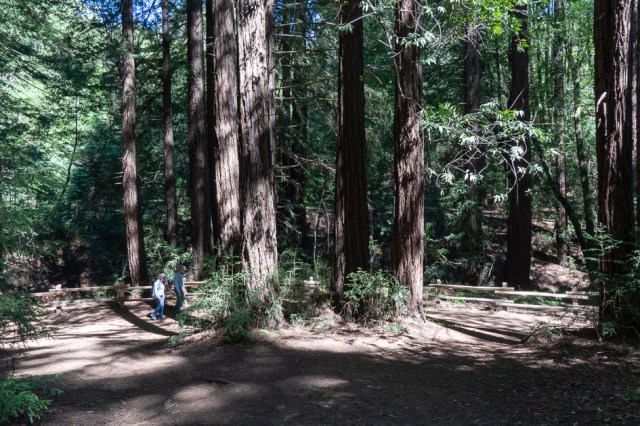
One such tour is Fantastic Caverns. Billboards advertising the Ride-Thru cave tours were a common sight along the freeways and roads throughout Missouri. Was this a hokey tourist trap or the real deal? We met up with our daughter and the grandkids to find out.

Jon, Maya, Laura, and Jackson pose with a cave explorer

Inside the visitor center, we found a gift shop and various displays to keep us busy while we waited for our tour to start. Once aboard, our driver/guide regaled us with the history and geology of the cave.

Display outside

Credit for the cave’s discovery goes to a dog who went missing in 1862. The dog had slipped through a hole in the ground and its owner followed it, stumbling into the cave. The dog’s owner, John Knox, kept the cave a secret to protect it from the Union and Confederate sides of the Civil War. The armies had seized several other caves to mine the limestone for the production of ammunition.

Tribute to the dog that started it all.

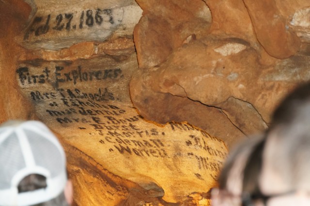
After the war, the Knox posted a newspaper advertisement requesting someone to explore the cave. The Springfield Women’s Athletic Club obliged and documented their presence on the cave wall on February 27, 1867.

Names of the first explorers (sorry about the fuzzy heads)

Since then, the cave has had many owners and has served as a meeting place, a speakeasy during prohibition, a concert hall, and a broadcast studio in the 1970s. The Ku Klux Klan is recorded as having been owners from 1924 to 1930.

My favorite type of cave formation are these columns that remind me of cauliflower or a fantasy forest.

At one point, our guide stopped the tram in one room. I should have taken better notes, because I don’t recall what she was showing here, but it had something to do with saltpeter or gunpowder.

The orange and black gives an eerie abstract look to this wall.

One hundred years after the cave’s discovery came the first Ride-Thru tour. The Campbell family arrived in 1966 to manage the tours and in 1992, they purchased the property that included the cave. In 2017, LED lighting replaced the early 1970s lighting system.

View of one of the side rooms

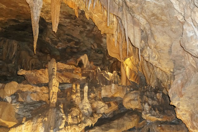
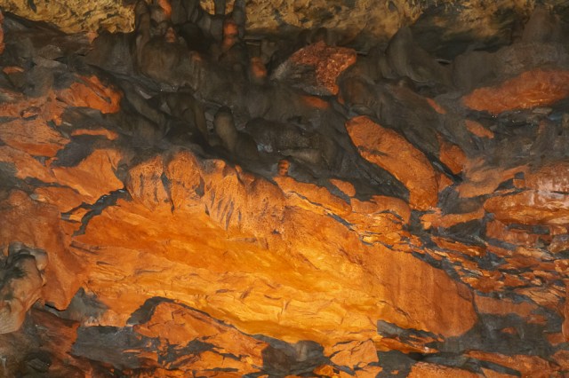
An ancient underground river created the usual formations common to caves: stalactites, stalagmites, columns, soda straws, flowstones, cave pearls, and draperies. Water still drips from above, a sign the formation of limestone process continues.

Baby drapery formations hang from the ceiling
This drapery formation has had a long life.
Can you find us hiding in the tram?

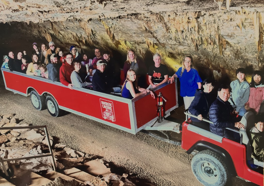
So what was the hokey verdict? Not hokey. The visitor center includes a gift shop with cave and geological themed items to purchase. And we had fun riding the tram with an informative and entertaining tour guide. We recommend Fantastic Caverns for anyone, young or old or anywhere in between, to hop aboard the tram and take a ride among the formations.

Bring a sweater or light jacket to ward off the chilly 60-degree temperature. And tall people should sit on the right side because the tram comes close to low-hanging formations on the left side.

Up Next: Top of the Rock Heritage Preserve in Branson, Missouri.

Hawaii June 2022 Trip: Episode 4

On some days, we didn’t have a specific activity or destination in mind, so we just poked around. Some of us attended church, then we all visited the Kauai Coffee Estate, the Fort Elizabeth State Historical Park, and we ended our day at the Spouting Horn Blowhole.

Old Koloa Church

The history of the Old Koloa Church dates back to when missionaries first arrived in Kauai in 1820 and when Reverend Peter Gulick established the first mission in Koloa in 1834. Native grass houses served as meeting spaces until the mission constructed its first meeting house in 1837. Destroyed during a storm in 1858, the church was reconstructed and opened its doors in 1860. The congregation was formally organized in October 1923 as the Koloa Union Church and occupied the building until it moved next door in 1953. Pastors Harold and Christy Kilborn have led the current congregation at The Church at Koloa since 1981. Inside, the architecture is cozy and welcoming, as are the congregants and the pastors.

Old Koloa Church

Kauai Coffee Estate

On a visit to Kauai Coffee Estate, we learned the estate operates the largest coffee farm in the US. Not just in the State of Hawaii, but the entire US. We took the self-guided tour around the visitor center where there were places to stop and read information signs that talk about growing and preparing the coffee for packaging. After our walk, we purchased a pound of roasted beans to take home and bowls of ice cream to eat on the patio at the back of the visitor center. It seemed only right to choose coffee ice cream at a coffee estate. My first bite stirred memories of sitting with my grandmother on her front porch after dinner, digging into a bowl of coffee ice cream, and watching the sun set behind the houses across the street. Ah memories. What would we do without them?

Kauai Coffee Company Visitor Center
Signs lead the way around the visitor center

The estate did not always grow coffee. For over 100 years, sugarcane stretched from Koloa in the south to Kalaheo in the west. Plantings of coffee trees began in 1987 and now total 4 million. One tree grows one pound of coffee a year. I wish we could have squeezed two pounds of roasted beans into our luggage.

This piece of equipment drives over the trees and “tickles” the cherries off.
This shed sorts the cherries by maturity: ripe, natural, and immature
Logo stamped in the concrete walkway around the visitor center
Rows upon rows of coffee trees. Note the Cook Pines at the end of the row.
Hibiscus plants are common in Kauai. Love their paper-like petals.
Ripe coffee cherries

Among the coffee trees, we found a noni (Morinda citrifolia) tree, a member of the coffee family. With an odor so strong, the noni fruit may make one gag. Despite its awful stench, it’s believed to have health benefits and is often made into a beverage, powders, lotions, or soaps. Oil is made from the seeds and the leaves are ground to a powder and encapsulated into pills. Not enough fresh food to eat? Substitute noni as emergency food during famines. I hope I never have to resort to such a substitute.

Noni fruit

Ranchers brought 105 Cattle Egrets to Kauai in 1959 to control insects pestering their cattle. Today, they are the pest raiding the nests of Hawaiian duck, stilt, and other birds. In 2017, the state issued a control order calling for the culling of the birds from a population of over 30,000. Unintended consequences have the egrets running amok on the island.

Cattle Egret

Pa’ula’ula/Fort Elizabeth State Historical Park

There’s not too much to see at this state park that we could find. There are information panels that tell the history of the site with a map of what the Russian fort looked like, a rock wall, and a statue. We walked around the wall searching for the opening to the center and instead found the coastline.

Waimea river meets the ocean
Looks like a nice uncrowded beach to spread out a towel

On our way back to the car, we guessed the wall outlined the fort, and I neglected to take a photo. Was the entry blocked or hidden? Had we missed the opening? Then I noticed the statue across the field from the parking lot. It looked new and well tended.

The Russian Fort Elizabeth State Historical Park was designated a National Historical Landmark in 1962 and the State of Hawaii acquired the property in 1972. On the Fort Elizabeth.org website, they list plans for the 17-acre site, including a visitor center. One of their plans was to honor King Kaumuali‘i, the last king in Kauai, with an 8’ bronze statue. This we found.

Statue Honoring King Kaumuali‘i

The king faces toward the setting sun on the day of the spring equinox, allowing him to enjoy the sunset of the winter solstice to his left and the summer solstice to his right. A small and large crescent in the floor pattern represents moon phases and the past and present.

I hope to come back once the center opens to welcome visitors and learn more about the fort, the king and all the historical figures that set foot on the site. For more information, visit the websites at National Park Service (https://www.nps.gov/places/russian-fort-fort-elizabeth.htm) and Fort Elizabeth (http://www.fortelizabeth.org).

Spouting Horn Blowhole

The Spouting Horn blowhole is a popular tourist stop. Whether they are walking, riding a bike, in a car, or on a bus, they come to take photos. Since this is one of the most photographed spots in Kauai, I joined in and set my camera on continuous shooting to capture the action. It was thrilling to watch the surf crash into the rocky shore and spout up through a hole in the rock like a geyser in Yellowstone. The gushers can reach up to 50 feet, depending on the tide level.

Spouting Horn view from left side of overlook

The hiss and roar that the water makes as it squeezes through a lava tube is the basis of the Hawaiian legend of Kaikapu, a giant moo, or lizard. There are multiple versions of the legend, as is common with legends. Was Liko a young boy who tricked Kaikapu, or was he a fisherman?

On the right side of the overlook, sea turtles played in between the rock formations. I couldn’t get close enough for a photo.

Whoever he was, he stabbed or speared Kaikapu in the mouth, swam under the lava shelf, and escaped through a lava tube. Kaikapu followed and got stuck in the tube. It is his moans and groans that create the hiss and roar. Or it could be her, depending on the legend. Who knows for sure?

Here a chick, there a chick, even at the blowhole

More to come in episode 5. See you then.

Safe Travels

Updated: August 20, 2022, to correct wording under the Old Koloa Church heading.

Where Have the Traveling Todds Gone? Or, A Bad Break on April 8

Our plan to visit more of the East Bay Regional Parks fizzled the day it began. On April 8, 2022, we selected the Black Diamond Mines Regional Preserve for our first visit. Since the green hills near us had already begun their fade to gold, we knew the wildflowers wouldn’t last much longer in the eastern part of Contra Costa County.

View of hills from Black Diamond Mines parking lot. The last clump of trees in the background surrounds the Rose Hill Cemetery.
Plaque commemorates the Mount Diablo Coal Field where twelve major mines supported five communities during 1860 to 1906.

We started out on the Atlas Mine trail until we encountered a closed sign, then transitioned to the Chaparral Trail. A few days earlier, I had watched a video about the wildflowers on the Chaparral Trail and anticipated all the wildflowers I’d be able to capture with the camera.

Up two short inclines and a walk through an overgrown area, until we hit a clearing where I stopped to take photos. Then Jon realized he had dropped the map. I offered to navigate the inclines again to retrieve said map. Sandstone isn’t my favorite medium to hike on, so I was proud I made it down and back up the steep inclines, not just once, but twice without sliding.

Hazel Atlas Portal trail ended at a closed sign.

With the map retrieved, we continued on a maintenance and fire road, also graded from sandstone. I found another patch of flowers to capture with the camera and squatted to get a closer view. With the picture taken and the camera turned off, I stood, then landed on my butt.

Pain gripped my right hand and wrist. My Lamaze breathing techniques kicked in. Between breaths, I prayed for a sprain and not a break. I didn’t want to look, I couldn’t look, I had to look.

Rough Cat’s-ear

A quick look revealed my right hand misaligned with the arm. Not a sprain. Dizziness and shaking left me sitting in place for several minutes until I could recover and stand. My camera and strap served as a handy sling and kept the pain at bay.

Luckily, we hadn’t gone more than a 1/3 mile from our car. Off we drove to urgent care where X-rays confirmed the damage and need for surgery. Our plans to visit the East Bay Parks or traveling in our RV ended that day, a disappointment we are only recently getting over.

Yellow Trumpet

I’m sure it’s easy to guess that having my dominant arm immobilized limited what I can do. Jon has been the perfect caregiver helping me whenever I couldn’t do something on my own, carting me to doctor appointments and other outings, and taking over all the household chores.

On Thursday, July 7, three months later and two months after surgery, the doctor released me from any splint, cast, or brace. Now I’m looking at several months, if not a year, of slow incremental progress until my mobility returns to what it was before.

Ithuriel’s Spear

So, there you have it. A bad break sidelined the Traveling Todds and kept us from enjoying our passion for poking around this great nation of ours. We are so looking forward to packing up and hitting the road in a few weeks, after a few PT appointments and assuming no other obstacles crop up.

Thank goodness I could trade my cast for a brace, and we didn’t have to cancel our trip to Kauai with the family. It was a trip we had originally booked for April 2020 and rescheduled for early June 2022.

Stay tuned for a post or two, or more, about our Hawaii trip.

Safe Travels

Updated July 14, 2022: corrected date from June 7 to July 7

Spring 2022: Family Campground at Anthony Chabot and Lake Chabot Regional Parks, Castro Valley, California

Anthony Chabot Family Campground was our destination on March 20, 2022, only 22 miles away, to explore another East Bay Regional Park District (EBRPD) property. We arrived early for our four-night stay, set up, and went for a walk.

The campground, set in a grove of eucalyptus trees, includes 12 full hookup sites, 53 drive-up sites that can accommodate tents and smaller RVs, and 10 walk-in sites. All the sites have plenty of space between them and are large enough for a party of eight. We found site 5 to be the best for us since it was one of only two pull-through sites in the RV section, and on the patio side, it looked out over the grassy grove of tall trees that sloped down into a valley.

Site 5 is a pull through with a view of the grove

Animals in the park include coyotes who howl late at night and early in the morning. Bevys of doves that hid in the grass and scared us when they took flight in mass, calling out warnings to their family and friends. Turkey gobbles echoed through the trees and hills. On one walk, we saw two toms, their tail feathers fanned out, arguing with each other, and doing breast bumps like football players do on the field. Not sure where their harem of hens was hiding. Usually, we see turkey flocks sticking together with one tom guarding his harem, jakes, and poults.

Wild turkeys everywhere in the Bay Area

Signs warn of mountain lions and rattlesnakes. They didn’t worry us because we stuck to the main roads and trails where more people were around making noise. I figured the mountain lions preferred the turkeys as easier prey. Of course, I sure wouldn’t want to tango with a tom in protective mode.

New poison oak shoots

On the flora side, warnings include poison oak. New green shoots poked through the ground and fall-colored leaves still clung to older shrubs.

Anthony Chabot Regional Park

The 3,304-acre Anthony Chabot Regional Park opened in 1952 as Grass Valley Regional Park. As noted in the park’s brochure, the park was renamed in 1965 to honor Anthony Chabot, who built the first public water system in San Francisco and Oakland. Lake Chabot, designed by Anthony Chabot and built in 1874, was added to the Regional Park system in 1966.

Shower and restroom building brought to you by the Land and Water Conservation Fund

The reservoir provides an emergency water source for east bay communities. Combined, the Anthony Chabot and Lake Chabot parks total 5,059 acres and sit within the ancestral home of Jalquin, an Ohlone- and Bay Miwok-speaking tribe.

Overlooking the east shore of Lake Chabot
Overlooking the Redwood Canyon Public Golf Course
On Huck’s Trail

Spanish settlers and Franciscans came to the San Francisco Bay Area in the 1700s. In the 1800s gold-seeking miners, loggers, and trains arrived. Before all of those people came, some estimates place a group of 10,000 to 20,000 indigenous people in the Bay Area, possibly dating back to 6,000 years ago. Scattered near the water, across the valleys, in the hills, and inland, the small tribes of hunters and gatherers lived off the land and sea.

California poppies in bloom
Boat rentals can be had at the marina
Edible miner’s lettuce
Bermuda buttercup

By the early 1900s, diseases had caused a severe drop in the population of Ohlone- and Miwok-speaking people. In addition, many of the tribes from the Contra Costa and Alameda counties lost out on Federal funding and land for their people.

Shedding bark drapes across limbs
Unable to find the name. Any guesses?
On the Towhee Trail
Braken fern perhaps?

Reinhardt Redwood Regional Park

The park district renamed the Redwood Regional Park to Reinhardt Redwood Regional Park in 2019 in honor of Dr. Aurelia Henry Reinhardt. Dr. Reinhardt was one of the first five directors on the District’s Board in 1934. Her contributions included the preservation of redwoods and public open space.

We parked near the Fishway Interpretive Site, which sounded interesting when I saw it on the map. A pair of information panels detail the life cycle of the native trout that spawn in the creek and live in the Upper San Leandro Reservoir.

California Registered Historical Landmark No. 970 plaque placed on April 29, 1987, marks the place where three fish taken from the creek in 1855 led to the naming of the rainbow trout species. The assigned scientific name is noted as salmo iridia rainbow trout.

Historic Landmark No. 970

After reading about the life cycle of the trout, we crossed a stone bridge to Bridle Trail and made a loop for about 2-1/2 miles. Parallel to the Bridle Trail is the Stream Trail that spans from one end of the park to the other. In addition, the Anza Historic Trail, Skyline National Trail, and Bay Area Ridge Trail pass through the 1,833-acre park, which opened in 1939.

A bit of water flows in the creek
On the Bridle Trail

Our hike meandered through a redwood forest of third-generation growth. Giant redwoods once stood there, probably for one or two thousand years or more. By the mid-1860s, loggers had felled most of the magnificent trees, often taking the stumps as well. The redwood groves destroyed became the wood used to build homes and businesses in the San Francisco Bay Area.

Ferns and plenty of shade
Trillium perhaps?

The trees that populate the forest today grew in clusters from any stumps left behind. It’s easy to spot where the giants once stood, just look for the circle of trees surrounding a hole.

Find a circle of trees you’ll find where a giant once grew
Yes, it’s okay to look up
Site of old church where a cross-shaped foundation is still intact
Barbecue pit at Old Church

Work is in progress to restore Redwood Creek the rainbow trout to migrate. The park district placed fence barriers along the creek to protect the ponds and banks from damage caused by people and dogs.

Wrap Up

Research on this post left me burdened with sadness as I read about the loss of the magnificent Redwood trees and the indigenous people. The devastation caused by selfishness, greed, and power in the name of progress is a common story that spans all the states we have visited. No matter how many times I read similar stories, I’ll always weep.

On the bright side, we also learn of the people who stepped up to say, “No more,” and worked tirelessly to preserve and restore what had previously come to disastrous results. So, we give thanks to the East Bay Regional Park District, their employees, and volunteers as they carry on the mission set forth in the 1934 ballot measure that created the district. May they continue to save more land for recreational purposes so we may immerse ourselves in nature, away from the noise and chaos of the cities and suburbs.

Long-term travel is out of the question for us for the next two months as we await our Hawaii trip in early June. In the meantime, we hope to visit more parks within the East Bay Regional Park District and other locations while we keep our adventures close to home. We’ll publish a post now and then as we do.

Safe Travels