Payson, Arizona, Part One

We left the nearly 100-degree temperatures in Gila Bend for cooler weather in Payson, Arizona, on October 6, 2019. When our escort led us to the rear of Payson Campground and RV Resort, we cheered. Another week without freeway noise sounded good to us. The dusty roads and campsites surrounded by tall hedges and trees made us feel like we were in a National Forest campground.

Campsite at Payson Campground and RV Resort

Green Valley Park and Lakes

One of the highlights of Payson is the Green Valley Park and Lakes. The 45-acre property is home to the Rim Country Museum, the reproduction of the Zane Grey Cabin, and the Haught Family Cabin. Anglers are welcome to fish the well-stocked lake, sailors with non-gas powered vessels are invited to glide across the calm waters, and bird lovers will enjoy the waterfowl that live in the area or visit during their migration.

Green Valley Park Lake

Walkers, runners, and parents with children in strollers find the 1-mile concrete trail around the large lake and the amphitheater a great place to enjoy a bit of exercise. Children even have access to a playground.

Green Valley Park

The amphitheater is used for the 4th of July and Memorial Day events, summer concerts, and as we found out during our visit, the Annual Beeline Cruise-In Car Show.

Green Valley Park amphitheater

When we heard about the car show, we didn’t expect much. Cars had arrived from Phoenix and other Arizona locations as well as from neighboring states. Someone made an announcement over the PA system that this year’s event was the largest ever. They had slots for 225 cars but ended up with over 240. Fortunately, the group was able to accommodate everyone who arrived. Jon and I spent about two hours gawking at the classic cars and snapping photos.

If you’re not interested in photos of classic cars, just roll on down the page.

The Halloween Roadster
Ah, there’s the boy that made the music play, skulls rattle, and dog bark.
Delivery sedan
Mad Max car
Chevy Apache stepside pickup
Family picnic time
1948 Chevrolet Fleetmaster Country Club Convertible
At the Carhop
My first car was a white two-door 1970 Datsun 510 with a black vinyl top. I wanted the butterscotch color, but it wasn’t in stock. Fifteen years later when I could afford the aftermarket paint job it was time for a new car.
1980s icon Bob’s Big Boy
Jon owned a blue 1963 Volkswagen bug with a ragtop moon roof.
Payson’s first firetruck. The museum is taking donations for a restoration project.
Jon also owned a Metro after he crashed his 1955 Chevy
I don’t think this Jeep spends much time 4-wheeling

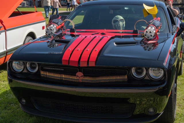
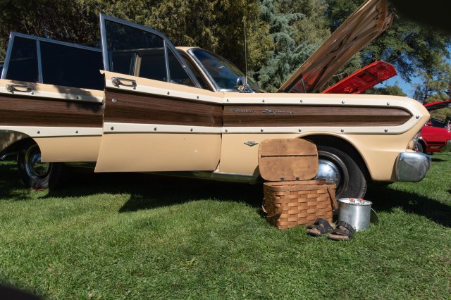
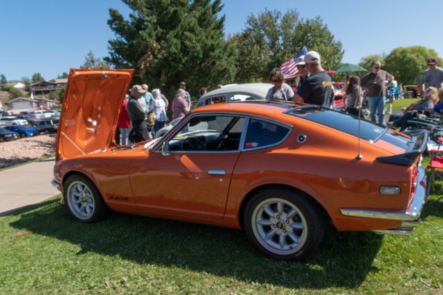
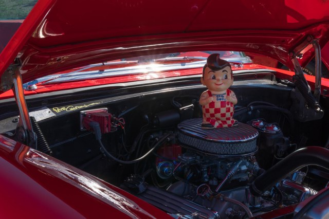
Taking photos with someone proves that photographers put their own personal spin on their photos. Jon took pics of the cars with their hoods up, showing off the power plant and/or the wheels and tires, while I took pics of quirky autos like the Mad Max, the Halloween Roadster, and Carhop.

Rim Country Museum and Zane Grey Cabin Tours

 The Rim Country Museum and Zane Grey Cabin are only viewed through a docent-led tour. Sadly, no photos are allowed inside the museum or cabin, and the museum’s website does not contain any photos. Only people lucky enough to travel to Payson and take the tours get to see the wonderful displays and artifacts inside. It is a small space, and I understand they need to limit how many people enter the museum. However, it would be nice if they shared their images so more people can enjoy the exhibits. Perhaps someday they can record a tour or take photos to post on their website.

The first National Forest Ranger building. Through the door and window are displays of objects used years ago.

The displays included artifacts and stories about ancient civilizations that populated the Rim Country, continued with early settlers, the June 1990 Dude Fire that took the lives of six firefighters and destroyed the original Zane Grey cabin, and a feud deadlier than the Hatfield-McCoy feud. The Pleasant Valley War (also known as Tonto Basin Feud, Tonto Basin War, or Tewksbury-Graham Feud) racked up an estimated death toll of 35 – 50 from 1882-1892, while 13 people died during the Hatfield-McCoy feud. For those interested in learning more, Wikipedia has detailed information on the conflict, and Zane Grey based his novel entitled To The Last Man: A Story of the Pleasant Valley War on the war.

Reproduction of Zane Grey’s Cabin

Through architectural plans, the historical society was able to recreate the Zane Grey hunting cabin. The structure contained one large room that served more like a meeting room than a place to sleep and cook. In fact, there were no facilities for cooking and sleeping. The hunters must have cooked and slept outside in tents.

Zane Grey Cabin replica

The docent-led tour of the Zane Grey Cabin included historical background of the author ‘s life, his time in Rim Country, and his career as an author. Grey’s books line the shelves and his typewriter sits prominently on the desk. Apparently, years after Grey’s death, his wife was cleaning out and giving away belongings. She gifted the typewriter to a young man who worked for her. He kept the typewriter safe for many years until one day he arrived and donated it to the museum.

The Haught Cabin

The Haught cabin is also on the premises at Green Valley Park and Lakes. Imagine living in a 10’ by 18’ dirt-floor cabin without windows with five children and a mother-in-law. That is what Sarah Haught did after she and her husband Henry arrived in the Arizona Territory from Oklahoma in 1897. Territorial settlers sure were hardy folk.

Haught Cabin
The cabin is staged inside as if only one person lived there, not eight. Did hammocks hang from the walls?

When the nearby spring dried up, they took apart their little cabin and moved it to Little Green Valley where they settled next. Years later, Henry and Sarah’s daughter continued the family tradition by living in the log cabin with her husband Henry Garrels and their 5 sons. When Larry Hammon acquired the property in 1999, he contacted the Rim Country Museum to see if they were interested in relocating the structure. Again, the cabin was dismantled and then rebuilt where it now stands next to the museum.

Restaurants

While in Payson, one must eat, so we tried out a few local restaurants. We stopped in for lunch at Miss Fitz 260 Café. I had a cheeseburger with potato salad (with bacon, yum), and Jon chose chicken fried steak. We both enjoyed our meals with Arnold Palmers.

We felt privileged that Duza’s Kitchen had room for us at lunch. The comments about Mensur Duzic, the owner and executive chef, and her restaurant in Phoenix were glowing, and previous customers promised a drive to Payson for her food. The turkey, bacon, and avocado sandwich on Asiago bread was delicious.

Duza’s Kitchen
Mensur Duzic is the woman on the left

Fargo’s Steakhouse was the perfect setting for celebrating the one-year anniversary of my surgery and Jon’s pain-free back and recovery from Bell’s Palsy. The menu offered so many choices that they are sure to please everyone’s palate. We enjoyed good food, great service, and best of all, spending our special day together.

Fargo’s Steakhouse has much more than steak

That’s enough for now. Stay tuned for next week’s post when we venture outside the city limits.

Safe Travels

Respite in Gila Bend, Arizona

Peace and quiet and wide-open spaces are what we needed after the big city sights and sounds of San Diego. Although temperatures approached 100 degrees, Gila Bend KOA seemed like the perfect spot to get away from the ants that invaded our coach and the roar of the freeway outside our bedroom window.

The Ranch House at Gila Bend KOA

We checked in at Gila Bend KOA on October 3, 2019, for a three-night stay. This RV park has been our go-to campground whenever we pass through the Sonoran Desert. Each year we arrive anxious to see what improvements the owner Scott Swanson has made since the previous year. A major street resurfacing project was underway when we arrived, closing off the main road. Our escort led the way along an alternate route to our site. This was the best site we have ever had at this campground.

Our campsite at Gila Bend KOA

A new gate at the entrance prevents people from entering that do not belong. Unless I missed it during our last visit, the Solitary Confinement shelter was a great addition for folks who want to enjoy a little solitude.

Step right in for your solitary confinement

Chairs have been placed inside the two cubicle-like spaces with a view of the usually dry creek lined with palo verde trees. Don’t even think about talking while cocooned in solitary,  it’s not allowed. And pets and loved ones must stay at home.

View from the Solitary Confinement

Patio and fireplace behind the Ranch House

Although Gila Bend boasts a Dollar General, Family Dollar, and a Carniceria, for shopping we prefer to drive to Buckeye for our groceries. The Butcher & The Farmer Marketplace had everything we needed under one roof.

The Butcher & The Farmer Marketplace in Buckeye has everything you need

We took Old US 80 to Buckeye, a scenic route that winds through farmland, around lava flows, and past The Co-op Grill.

They went thataway

Operating farms and dairies and smaller ranchettes also lined the road. Dotted here and there were a few properties that appeared abandoned.

Acres of cotton fields
A cotton blossom

The highlight of the drive is the Historic Gillespie Dam Bridge and Interpretive Plaza. Unfortunately, someone had removed the interpretive part of the plaza leaving only the sign supports. Never fear, Wikipedia to the rescue to fill in the details of the artifact’s history.

The interpretive Plaza lacked information signs

The concrete gravity dam on the Gila River was constructed during the 1920s for irrigation purposes. In 1927, the steel truss bridge opened to traffic and incorporated into the highway system as Route 80.

View of Gillespie Bridge

It carried US 80 traffic until 1956 when the bridge was decommissioned. On May 5, 1981, the bridge earned its spot on the National Register of Historic Places.

The bridge across waters

It carried US 80 traffic until 1956 when the bridge was decommissioned. On May 5, 1981, the bridge earned its spot on the National Register of Historic Places.

The ramp to the overlook

Following extreme rainfall in 1993, a portion of the dam failed, remnants of which can be seen from the road.

Gillespie Dam

Driving through Buckeye we noticed the school looked like it had been recently renovated. Across the street stood a two- and three-story brick building that housed the city offices and chamber of commerce. It all seemed too fancy for such a small town until I learned the population approached 69,000 people, about 10 times what I thought, and was the fastest-growing town in the US during 2017.

Buckeye city offices
An homage to the cotton industry
Garden behind the city offices

Before we left Gila Bend for cooler climes in Payson, Arizona, we drove east on Interstate 8 to see if any progress had been made at Big Horn Station since our visit in February 2018. Our post, dated March 3, 2018, titled Gila Bend and Ajo, Arizona,  here provides more detail of the historic property.

Not much improvement happening at Big Horn Station

Refreshed from our respite in Gila Bend, it was time to move on. Payson, here we come. But before we go, here is a sunset photo.

Can there ever be too many sunsets?

Safe Travels

Palace of Fine Arts in San Francisco for Photo Workshop

We drove over the bridge and through The City to a motel near the Palace of Fine Arts on August 3, 2019. It was time for me to take advantage of a discounted workshop that came with my new camera purchase.

Palace of Fine Arts with foggy skies

I tried night photography a few times with no success. My dream of capturing the Milky Way or stars streaking across the sky always ended with a couple of itty-bitty dots on an otherwise black image. Here was my opportunity to learn how it is done.

Seagulls stake their claim on the heads of the weeping ladies

Wearing a T-shirt under a long-sleeve shirt, a jacket, and a knit cap, I arrived at the palace with my gear. Andy and Reza, the instructors from Mike’s Camera, traveled up and down the line of photographers assisting with settings, pointing out images to capture, and encouraging all of us to create the best photos we could.

Decorative panels surround the top of the rotunda

I shoot handheld about 98% of the time. Although I had practiced setting up the tripod the day before, I was not familiar with how to switch it from the landscape position to portrait. I needed assistance and in the process, I was gently advised that my tripod was a piece of junk (my words) and I should buy a better one.

Where did that blue sky come from? (ISO 100 23mm, f/8.0, 13″)

Pointing my camera at the sky above to search out stars was not possible, nor were we able to capture a golden hour sunset. Fog had already rolled in for the night and every once in a while the wind would blast my lens and face with mist.

Yellow lights color the foggy sky (ISO 250, 19mm, f/11.0, 15″)

So what is the Palace of Fine Arts and why was it built? Still recovering from the devastating earthquake of 1906, San Francisco hosted the Panama Pacific International Exposition (PPIE) in 1915.

Detail of weeping ladies

Architect Bernard R. Maybeck designed the palace for exhibiting art during the exposition. The Beaux-Arts style evokes Roman and Ancient Greek architecture and gives the impression of a Roman ruin with its colonnade, grand rotunda, and pond. The weeping ladies facing into the tops of columns may elicit a feeling of sadness and solemnity.

Colonnade

The Palace is one of 10 such buildings built for the PPIE. None of the temporary buildings were constructed to last beyond the exposition. Citizens of San Francisco thought the Palace too beautiful to meet the fate of a wrecking ball, so it was saved from destruction. After World War II, the building served as a military storage depot, a warehouse for the Parks Department, a telephone book distribution center, and temporary headquarters for the Fire Department.

Rotunda ceiling

In 1959, Assemblyman Caspar Weinberger led an effort to restore the Palace through public and private funding. Philanthropist Walter S. Johnson contributed $2 million to complete the restoration of the building into a permanent structure. In 1962, the Palace of Fine Arts League, a 506( c ) 3 non-profit was established and eight years later, the park, rotunda, and Palace of Fine Arts Theatre opened. Additional renovations of the lagoon, walkways, and a seismic retrofit were completed in early 2009.

One of the angels in the rotunda

Located in the Marina District of San Francisco, the Palace is a favorite location for photographers, marriage proposals, and weddings. Locals come for a stroll around the park, grab a seat on one of the many benches, and watch the sunset on fog-free evenings. With no sunset to view during our visit, we all waited for the lights to illuminate the structure and bath it in soft yellow and orange light.

Don’t harass the swans, they fight back.

I had fun at the workshop and am ready to sign up for another one. Like many photographers, I mostly learned the art form through books, online articles, video courses, and trial and error. The workshop introduced me to other people who are passionate about photography and eager to learn new skills. The major takeaway from the night, besides needing a new tripod, was learning to use the exposure triangle tools in my camera.

Obviously, one workshop does not make a night photographer. These photos are definitely not award-winning specimens. But I’ll experiment with settings and practice what I learned until I’m able to capture the sharpest image possible given the available light.

Safe Travels

The California Lost Coast and Humboldt Redwoods State Park

A few days among the giant redwoods sounded like a good idea before we concluded our 2014 Pacific Northwest adventure. We settled in at The Ancient Redwoods RV Park where the Immortal Tree stands. The tree survived a lightning strike that removed approximately 50 feet from its height in 1908 and a flood in 1964, two recent life-threatening events that have occurred during its 950 – 1,000 years.

Immortal Tree

Lost Coast

We drove around the next day and chanced upon one of those roads that made us ask, “I wonder where that goes.” Over bumpy terrain we traveled, up hills and down hills, through small settlements in the middle of what looked like nowhere until we arrived at Shelter Cove.

Mal Coombs Park

Cape Mendocino Lighthouse located at Mal Coombs Park in Cape Mendocino attracted our attention. First lit on December 1, 1868, the US Coast Guard abandoned the building at its original location in 1948 when it installed a new beacon light on higher ground. For the next 50 years, salt spray, punishing winds and torrential rains deteriorated the lighthouse until a group of citizens gained control, restored, and installed it at Mal Coombs Park.

Cape Mendocino Lighthouse

Near the lighthouse stands a statue and marker honoring Mario Machi, a founder of Shelter Cove along with his brothers Tony and Babe. The marker states he survived the Bataan Death March and three years of captivity in World War II. How wonderful that the man was so loved the town saw fit to honor him.

Beloved founder and resident Mario Machi

Not far from the lighthouse, we found tide pools to explore.

Crashing waves not far from tide pools

The clear water made it easy to spot sea life among the shallow waters.

Clear, clear water

I almost missed seeing the crab among the pebbles, shells, and bones.

Hey, what you looking at?

This was our first experience seeing a chiton shell. Our marine biologist friend later told us chitons are common. Thanks, Ray for educating us.

Chiton shell

Another first for us was the turban snails with their colorful purple and blue shells, definitely my favorite.

Turban Snails

A mile or so up the road along the coast we stopped for a photo op, catching a little wave action and capturing flowers nestled in the grass.

Coastline
Bouquet of flowers nestled in the grass

Humboldt Redwoods State Park

We never tire of walking among the California redwood trees and the Humboldt Redwoods State Park did not disappoint. The 53,000-acre park includes 17,000 acres of old-growth coast redwoods, the tallest known tree species in the world. They average in height from 150 – 250 feet tall and can exceed 350 feet, with a diameter of 20 feet or more. The bark on a mature tree can be one foot thick.

Searching for the top

Rather than a taproot like most trees, the root system of a redwood is shallow and extends up to 100 feet outward connecting with the root systems of other trees. I once heard on a podcast that trees communicate with each other and share resources through their root systems. If one tree needs nutrients to survive, the other trees will pitch in. The trees also possess a natural resistance to fire, disease, and insects, which contributes to their long life.

Jon and Linda standing by a root

The trees can live several 100 years or even more than 2,000 years. Consequently, they are the oldest tree species in the world. High winds and flooding are the trees’ enemies.

There’s the top

A tree can reproduce when one of its seeds germinate (a rare occurrence) or when a new tree sprouts from the root of a parent or from burls. Seedlings that survive can grow more than 1 foot per year.

Hey, here I am.

Besides the old-growth forest, the park contains 250 campsites for tents and RVs 24 feet in length or shorter, 100 miles of hiking, biking, and riding trails, and the scenic 32-mile Avenue of the Giants. Driving along the Avenue of the Giants at times is like driving through a tunnel lined with the magnificent trees.

Giant ferns for a giant tree

Thanks to Henry Fairfield Osborn, John C. Merriam, and Madison Grant, who formed Save the Redwoods League in 1918. Without their perseverance and fundraising, the trees may not have survived the loggers’ axes.

Have a seat, or maybe not.

Dyerville Overlook

On our way back to our temporary home, we stopped at the Dyerville Overlook near Garberville. We would have expected more water running in the Eel River during May. A little research revealed dams and diversions limit the amount of water that flows at this location. They also maintain sufficient water to sustain fish populations during the dry season and prevent the type of flooding that occurred in 1955 that destroyed the Dyerville settlement and the one in 1964 which wiped out four other communities.

Abandoned railroad bridge

The bridge once carried Northwestern Pacific Railroad traffic between Eureka and San Francisco. Sadly, the railroad suffered the same fate as the communities destroyed by the floods. The graffiti painted train engine shown in our Eureka, California, blog post may have once rolled over the bridge in its heyday.

We started this series with the tulips in Washington, and end with a couple more flowers of a different varieties.

Yum, yum, gettin’ me some nectar
Purple flower

Fifth Wheel Dreams

Throughout our travels on this trip, we continued to find fault with our little trailer and dreamed of the Cougar fifth wheel we saw in Washington. Along our route we stopped in at a dealer in Oregon and another one in Petaluma, California. After perusing the pamphlets and climbing in and out the various styles and sizes, we made our choice. One month later, we were the proud owners of a new truck and fifth wheel, enjoying the outdoors on a shakedown cruise.

We gained elbow room in our new trailer.

Since then we have checked out the new models of all brands at the annual RV show at our local fairgrounds and during our travels. To date we have yet to find another model or size that would suit us any better. After five years we are satisfied with our purchase. Now if we can get back on the road to enjoy it, we would be super happy campers. Soon. Hopefully, soon.

Safe Travels